Cross-Country Planning
This page covers the portion of Task C. Cross-Country Flight Planning from the FAA-S-ACS-8C Instrument Rating Airplane Airman Certification Standards.
Route Planning
IFR Fuel Requirements
- Be able to fly to first airport of intended landing, then to alternate, and still have 45 min reserve at normal cruise.
- 14 CFR §91.167 - Fuel requirements for flight in IFR conditions
IFR Routing
- First need to select a route from departure to destination
- What will ATC assign?
- What makes the most sense?
- What gives you largest fuel reserve?
- How's the weather?
- What is your airplane capable of?
- Performance
- Navigation
- Emergencies
- Also look at
- Departure procedures
- Preferred routes
- Listed in chart supplement
- TEC routes
- Agreement between Terminal Radar Approach Control Facilities (TRACON) e.g. Potomac Approach
- No need to talk to Air Route Traffic Control Centers (ARTCC) e.g. Washington Center
- Listed in chart supplement
- Listed for terminal areas and satellite airports
- Arrivals
- Approaches
- Alternates
Alternates Under IFR
- Start with the big picture
- Weather depiction chart
- Find the nearest good weather
- Often behind the weather system
- Back up with a forecast
- TAF within 5 nm
- If flying a non-WAAS-equipped plane, alternate must have an approach other than GPS
- If flying a WAAS-equipped plane, can use an alternate with only GPS approach
- Code 7700 Alternate IAP Requirements
- 14 CFR §91.169(c) - IFR flight plan: Information required
- When is an alternate airport required to be filed on an IFR flight plan
- 1-2-3 rule - an alternate is not required if:
- The desination airport has an IAP and
- From 1 hour before to 1 hour after arrival time weather is predicted to be better than
- 2000 ft ceilings and
- 3 sm visibility
- The desination airport has an IAP and
- If destination does not have an IAP, an alternate is required
- Even if the destination weather forecast is completely clear
- 1-2-3 rule - an alternate is not required if:
- When an alternate is required, then at the estimated time of arrival at the alternate airport, the ceiling and visibility at the alternate airport will be at or above the following weather minima, or it cannot be used as an alternate.
- Whatever is specified as the alternate minimums for that IAP
- If no alternate minimums are specificed:
- Precision approach: 600 ft ceilings, 2 sm visibility
- Non-precision approach: 800 ft ceilings, 2 sm visibility
- Or if there is no IAP, then weather good enough to allow descent from MEA, approach, and landing under VFR.
- Also note that you can file IFR to an airport without an instrument approach, and in this case you must have an alternate no matter what.
- So basically what you do is:
- Determine if alternate is required
- 14 CFR §91.169(a)(2)
- If destination airport doesn't have IAP - you need alternate
- If destination airport does have IAP - apply 1-2-3 rule
- If by the 1-2-3 rule an alternate is not required you are done
- If you need alternate, next have to determine if the desired alternate can be used
- 14 CFR §91.169(c)
- If desired alternate does not have IAP, weather at the ETA must allow descent and landing under VFR to use as alternate
- If desired alternate does have IAP, review it (or multiple IAPs that the aircraft is capable of) and see if there are alternate minimums listed.
- Otherwise apply standard minimums to determine if the desired alternate can actually be used as your alternate based on weather at the ETA
- Determine if alternate is required
- Note: if during flight you arrive at intended destination and cannot land due to current weather, you need not go to the filed alternate. If the weather is different than what was forecast during flight planning and there is a better alternate, use that instead.
- If flying a non-WAAS-equipped plane, alternate must have an approach other than GPS
- If flying a WAAS-equipped plane, can use an alternate with only GPS approach
- AIM 1-2-3(d) Alternate Airport Considerations
- Code 7700 Alternate IAP Requirements
- Discuss ADM around alternate planning
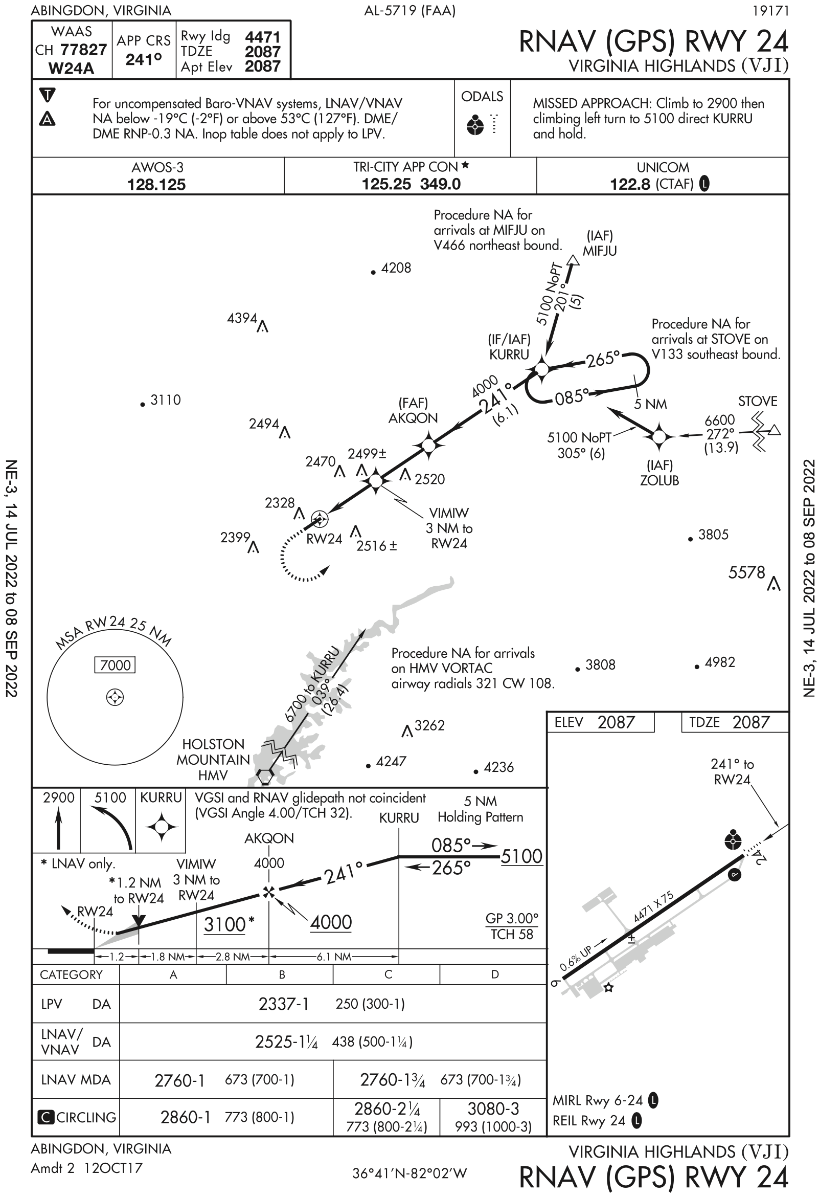
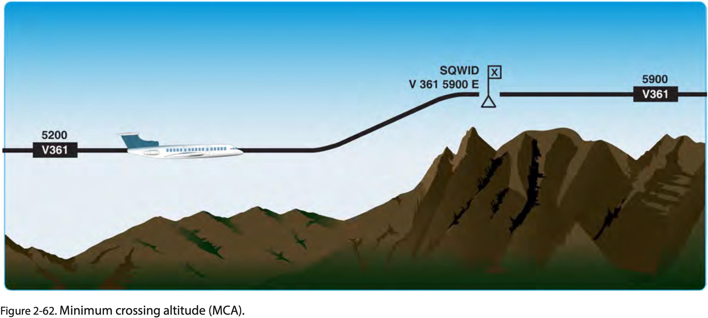
A in the triangle within the first box of the middle briefing strip notes box.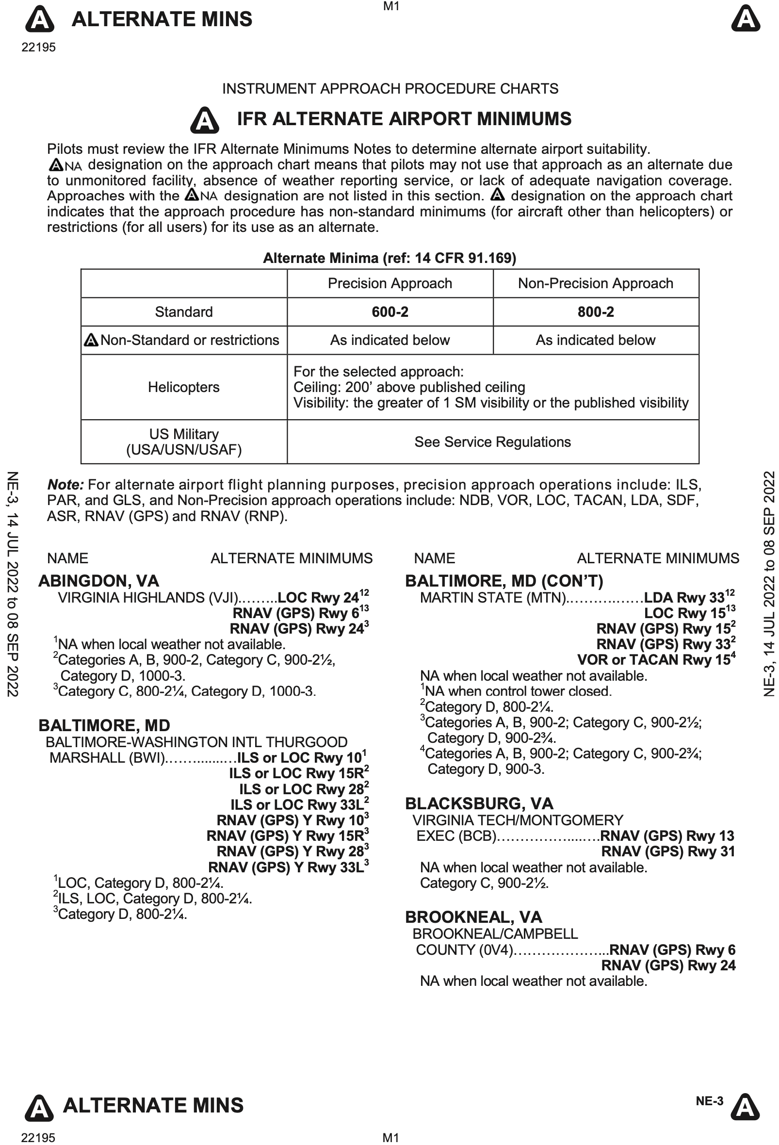
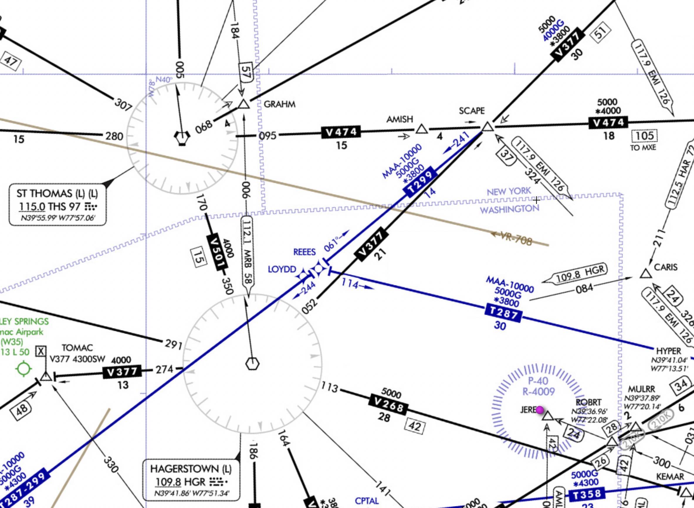
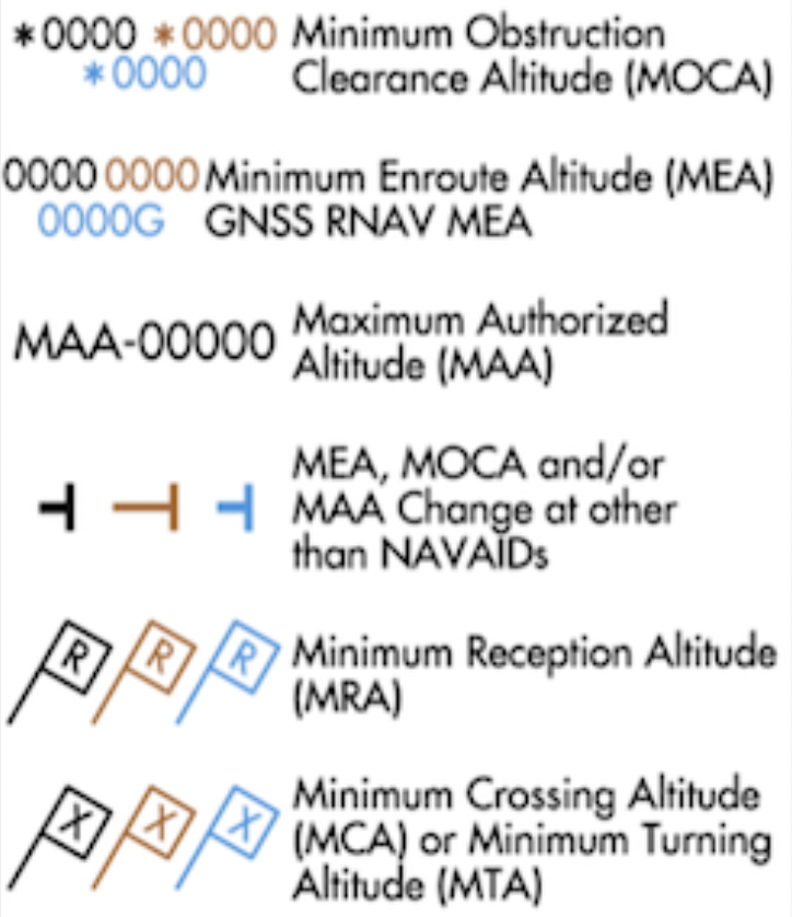
IFR En Route Charts
- See the FAA document Aeronautical Chart Users' Guide IFR Enroute Charts for descriptions of terms and symbols used on IFR enroute charts.
- Updated every 56 days
- IFR low chart is used under 18,000 ft.
- Victor airways - from 1200 AGL up to but not including FL 180
- T-Routes - like victor airways but for GPS navigation on IFR low charts
- Can use T-Routes with a suitable GPS
- On IFR high charts these are Q-Routes
- AIP ENR 3.3 Area Navigation (RNAV) Routes
- AIM Chapter 1 Section 2 Performance-Based Navigation (PBN) and Area Navigation (RNAV)
- Magnetic Reference Bearing (MRB)
- Published magnetic bearing between two waypoints on an RNAV/GPS/GNSS route
- Used to enhance situational awareness by associating magnetic course with GPS leg to check against compass
- Blue or green airports on IFR chart have instrument approach procedure (IAP) and/or radar minima, where this is related to ASR or PAR (radar) approaches
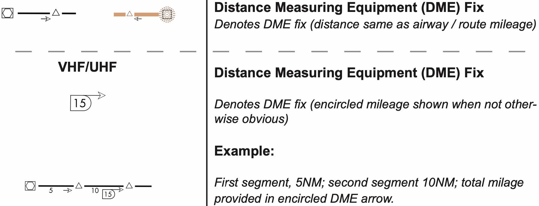
DME Distance Arrows on Low Enroute Chart

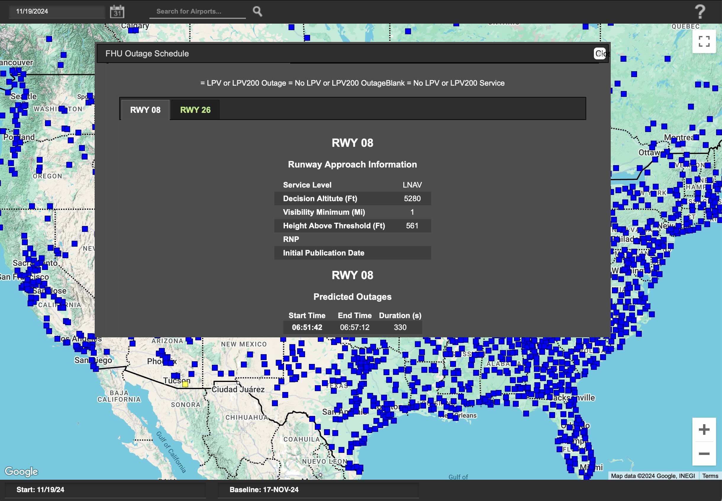
Notices to Airmen (NOTAMs)
- Two types
- FDC (Flight Data Center)
- Regulatory changes, approach procedures, aeronautical charts
- GPS
- GPS NOTAMs must be checked before using a GPS under IFR
- D
- Airport and airport facility changes
- Examples: temporary outages, runway closures
- FDC (Flight Data Center)
- NOTAMs with short effective period will be received with weather briefing
- If NOTAM will remain in effect for at least 7 days they will be published in the Notices to Airmen publication
- This publication has been discontinued
- Can obtain NOTAMs from
- Foreflight
- Online
- FAA
- 1800wxbrief.com
- Calling 1-800-WX-BRIEF Briefing (see: https://www.faa.gov/about/office_org/headquarters_offices/ato/service_units/systemops/fs/alaskan/alaska/fai/pfpwb/)
- Q: I assume Foreflight gives all NOTAMs with briefing, not just short term NOTAMs?
- FAA FNS NOTAM Seach
Preflight Information
- Before a flight, PIC must become familiar with all available information concerning that flight which includes (NWKRAFT)
- N - NOTAMs
- W - Weather
- Reports and forecasts
- K - Known traffic delays
- As advised by ATC
- See FAA National Airspace System Status
- R - Runway lengths
- Of intended use
- A - Alternates
- Available
- F - Fuel requirements
- T - Takeoff and landing performance
- Data
- The above list though is not comprehensive
- Route of flight and altitude
- Airspace
- Obstacles
- Airport environment at destination (taxi destination)
- Planned instrument approach procedures and potential alternate approaches that might be likely
- 14 CFR §91.103 - Preflight action
- IFR Fuel Requirements
- Be able to fly to first airport of intended landing, then to the alternate, and still have 45 min reserve at normal cruise.
- 14 CFR §91.167 - Fuel requirements for flight in IFR conditions
Overview
Global Navigation Satellite System (GNSS)
The generic term for satellite based navigation systems used around the world.
- As the title implies, satellite based navigation uses signals from satellites to determine location.
- These satellites are placed in a medium-Earth orbit.
- There are four constellations of such satellites operated by various bodies around the world:
- GPS - United States
- GLONASS - Russia
- Galileo - EU
- BeiDou (BDS) - China
Global Positioning System (GPS)
The particular GNSS system used in the United States.
- Given GPS is the system used in the United States, this document will refer to GPS, but much of what applies to GPS applies to the other GNSS systems as well.
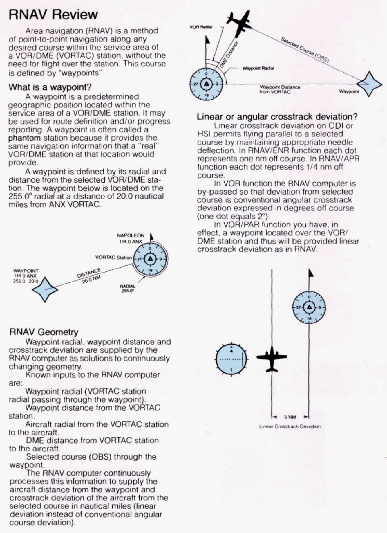
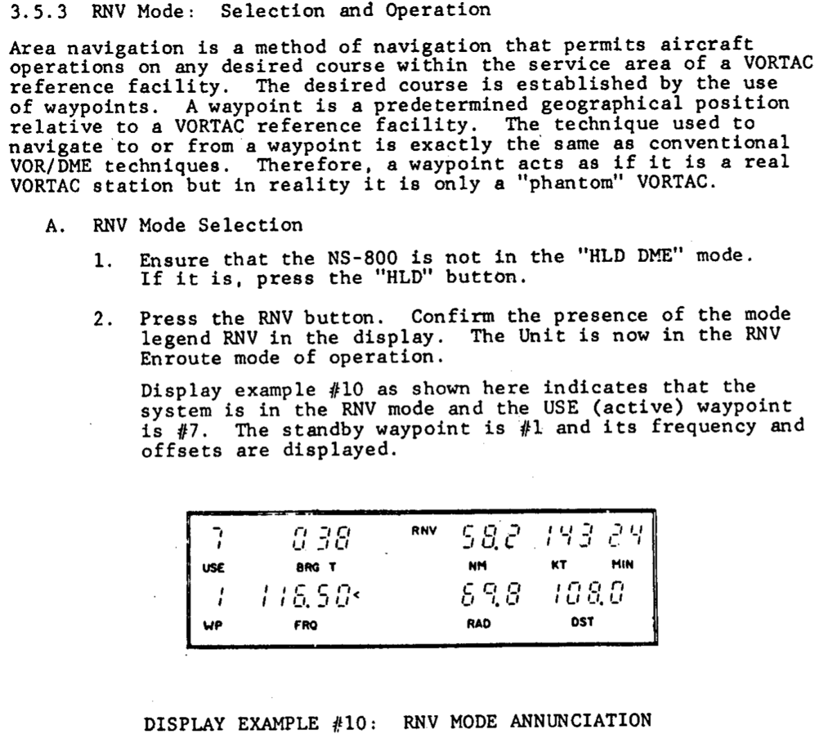
A History of Area Navigation (RNAV)
A method of navigation that permits aircraft operations on any desired flight path.
- GPS systems provide a capability called Area Navigation (RNAV) which, unlike using a traditional VOR receiver which only allows flying toward or away from the ground station, allows the navigation between arbitrary points.
- As GPS is overwhelmingly the means by which modern RNAV is possible these terms are often conflated.
- It is important to remember that they are distinct concepts, and while GPS can provide RNAV capability, RNAV systems did exist prior to GPS.
- Methods of area navigation that predate GPS include
- Visual reference (e.g. stars)
- Inertial Navigation Systems (INS)
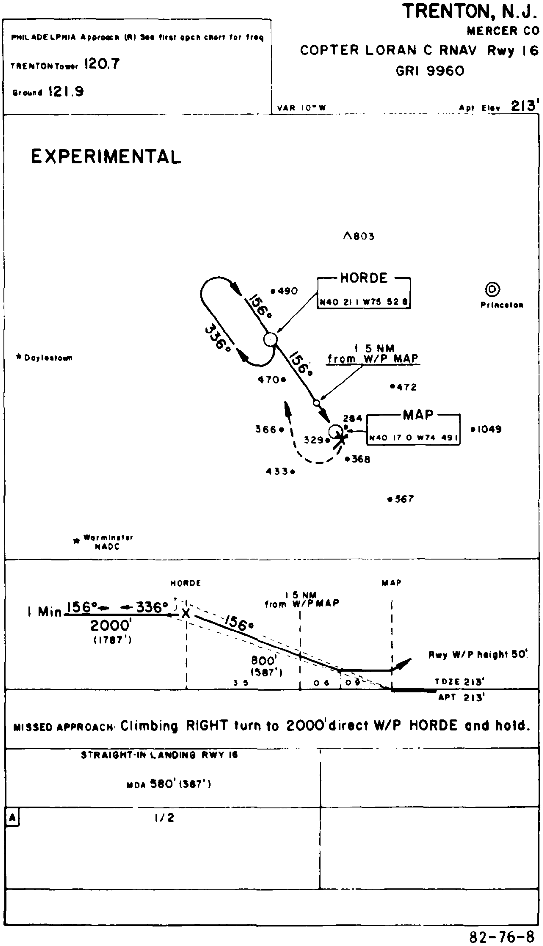
- LORAN C
- See FAA-AC-90-92
- VOR/DME
- DME/DME
- See FIU RNAV
- Some such VOR based RNAV recievers include
- The Bendix/King KNS 80 Digital Area Navigation System is an RNAV receiver based on VOR
- Narco NS-800
- King KN-74
- They enabled flight between waypoints that were defined by VORs, but without having to fly along the radials of VORs
- FAA-AC-90-45A Approval of Area Navigation Systems for use in the US National Airspace System from 1975 describes guidelines for RNAV systems, well before the existence of GPS
- With a little bit of background on legacy RNAV systems, we can now focus on GPS.
GPS Satellites
- The GPS constellation currently consists of 31 operational satellites
- GPS is designed so that as long as 24 GPS satellites are working, at least 5 should be visible at any time
- AIM 1-1-17(a)(3)(a)
- Need 4 satellites to have GPS
- This gives latitude, longitude, altitude, and time
- Need 5 satellites for RAIM
- More on RAIM below
- Need 6 satellites to remove corrupt GPS signal
- Need 4 satellites to have GPS
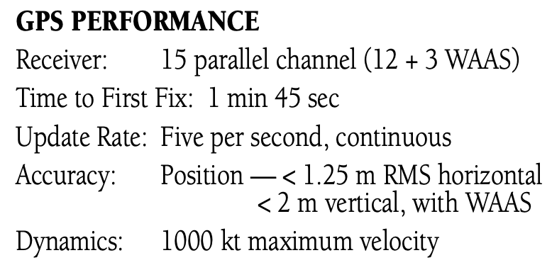
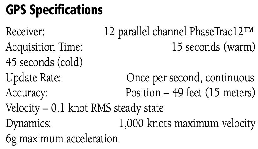
GPS Receiver
- A typical GPS receiver has at least 12 channels
GPS Database
- GPS databases are updated every 28 days
- Usually every 4th Thursday of the month
- Pilots can update GPS database if they can do it from instrument panel without special tools or disassembly of the unit
- Take the SD card out and update it
Performance Based Navigation (PBN)
Performance Based Navigation (PBN) is comprised of Area Navigation (RNAV) and Required Navigation Performance (RNP) and describes an aircraft's capability to navigate using performance standards.
AIM 1-2-1 says:
PBN exists under the umbrella of area navigation (RNAV). The term RNAV in this context, as in procedure titles, just means “area navigation,” regardless of the equipment capability of the aircraft.
This can be confusing given the difference between RNAV as a concept (area navigation) and RNAV as a navigation specification similar to RNP.
PBN defines a set of standards and doesn't depend on a particular technology.
Therefore, procedures can be defined that depend on these standards and can be used without being changed as new technology is developed.
RTCA DO-229 defines these standards.
These standards, refered to as NavSpecs apply to both aircraft and aircrew.
It also doesn't help that ICAO and the FAA differ somewhat in their use of terminology.
For an aircraft to meet the requirements of PBN, a specified RNAV or RNP accuracy must be met 95 percent of the flight time.
NavSpecs should be considered different from one another, not “better” or “worse” based on the described lateral navigation accuracy.
As a safeguard, the FAA requires that aircraft navigation databases hold only those procedures that the aircraft maintains eligibility for. If you look for a specific instrument procedure in your aircraft's navigation database and cannot find it, it's likely that procedure contains PBN elements your aircraft is ineligible for or cannot compute and fly. Further, optional capabilities such as Radius-to-fix (RF) turns or scalability should be described in the AFM or avionics documents. Use the capabilities of your avionics suite to verify the appropriate waypoint and track data after loading the procedure from your database.
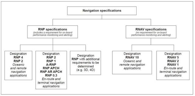
Required Navigation Performance (RNP)
- RNP is a navigation specification under Performance Based Navigation (PBN)
- Three standard RNP levels, where the value is nautical miles each side of centerline that must be maintained for aircraft and obstacle clearance
- RNP 0.3 – Approach
- RNP 1.0 – Departure, Terminal
- RNP 2.0 – En route
- The performance requirements of PBN are conveyed to the operators through navigation specifications, or NavSpecs.
- The values listed above are the lateral limits, in nautical miles, of the errors within which the system must remain 95% of the time
NOTE
RNP Requires
- A specified accuracy be met 95% of the time
- Onboard performance monitoring and alerting
RNAV Navigation Specification
- AIM 1-2-1(a)
- The term RNAV X means a specific navigation specification with a specified lateral accuracy value.
- No requirement for onboard performance monitoring and alerting.
Aircraft Equipment Requirements
- The Piper Archer III NXi G1000 system satisfies the following requirements:
- RNP APCH (without RF)
- RNP 1 (terminal operations)
- RNAV 1 and RNAV 2
- RNP-10 (oceanic and remote continental operations)
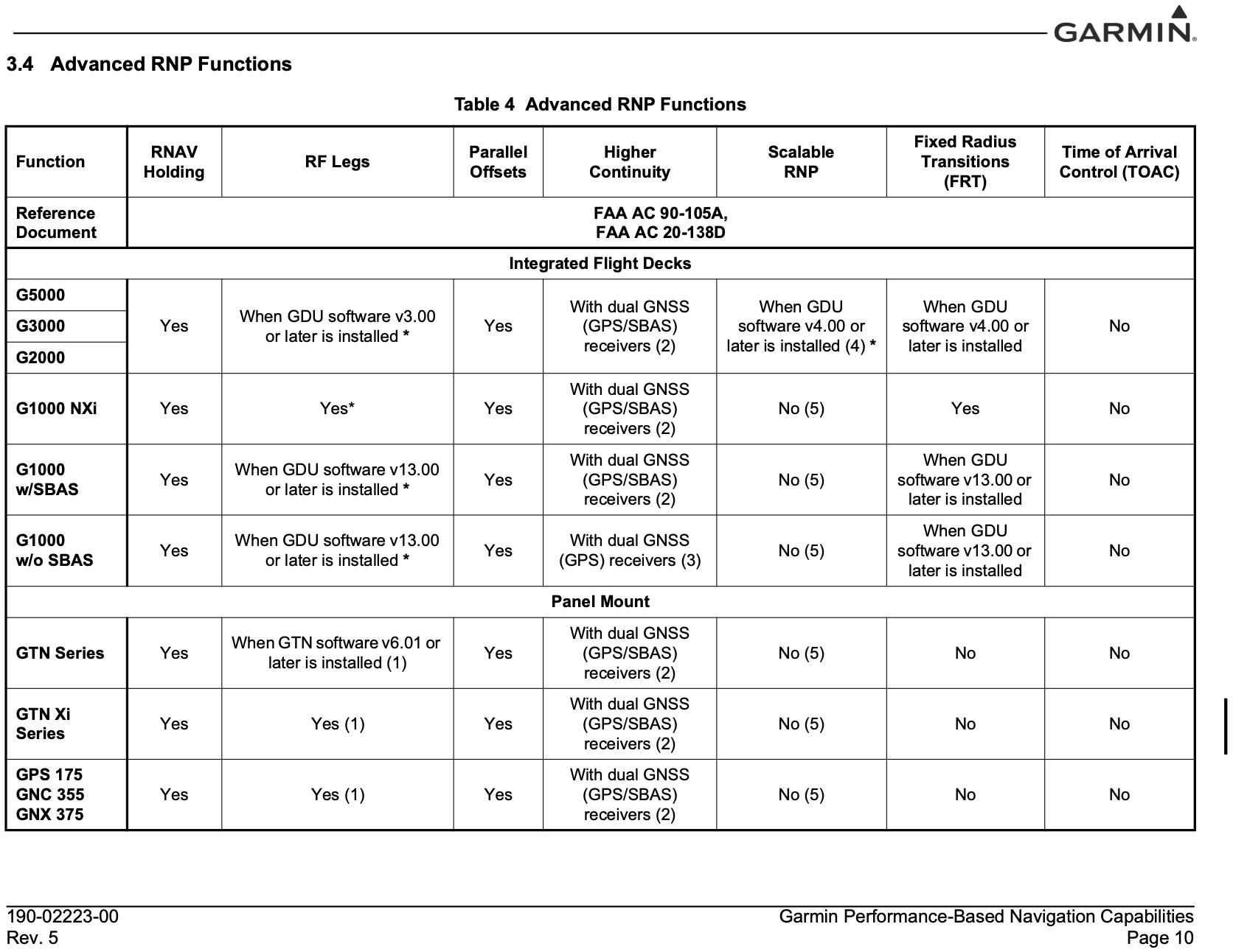
- Determining what requirements a particular aircraft satisfies can be challenging.
- The excerpt from Garmin Performance-Based Navigation Capabilities document indicates some RNP functions for various products
- Some capabilities depend on software versions, so be sure to check carefully what RNP capabilities an aicraft has before flying
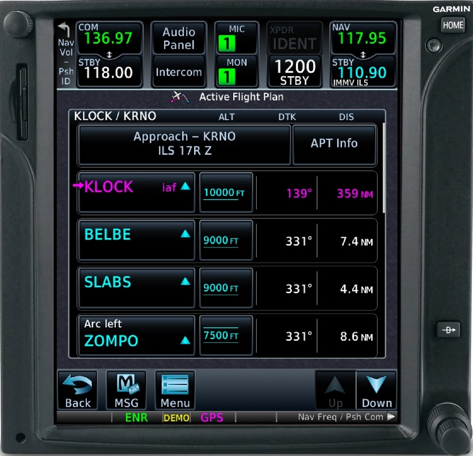
- The Garmin GTN750, which can support RF legs, are indicated in the flight plan view as shown below
RNP AR APCH (AR for Authorization Required)
General aviation operations do not have the authorization required to fly these approaches
In the U.S., RNP AR APCH procedures are titled RNAV (RNP). These approaches have stringent equipage and pilot training standards and require special FAA authorization to fly. Scalability and RF turn capabilities are mandatory in RNP AR APCH eligibility.
Relevant Advisory Circulars
- FAA-AC-91-105A for RNP definitions
- FAA-AC-91-100A for RNAV definitions
- FAA-AC-91-107 for LP and LPV approaches
- FAA-AC-90-101A for RNP procedures with AR
- FAA-AC-20-138D for airworthiness approval
In the past, LNAV/VNAV required a baro-aided altimeter
This has changed to allow appropriately certified WAAS GPS systems to fly LNAV/VNAV approaches, but I don't know exactly when this happened
- One data point is in the 2012 version of the AIM, which states that properly certified WAAS received will be able to fly LNAV/VNAV approaches
- Earlier references indicate the ability to use an appropriate WAAS GPS for LNAV/VNAV approaches
- WAAS was authorized for IFR use in 2003, so certainly before that LNAV/VNAV approaches would have required a baro-aided altimeter
- FAA-AC-90-97 (which was canceled by FAA-AC-91-105A) describes the use of barometric vertical guidance for VNAV

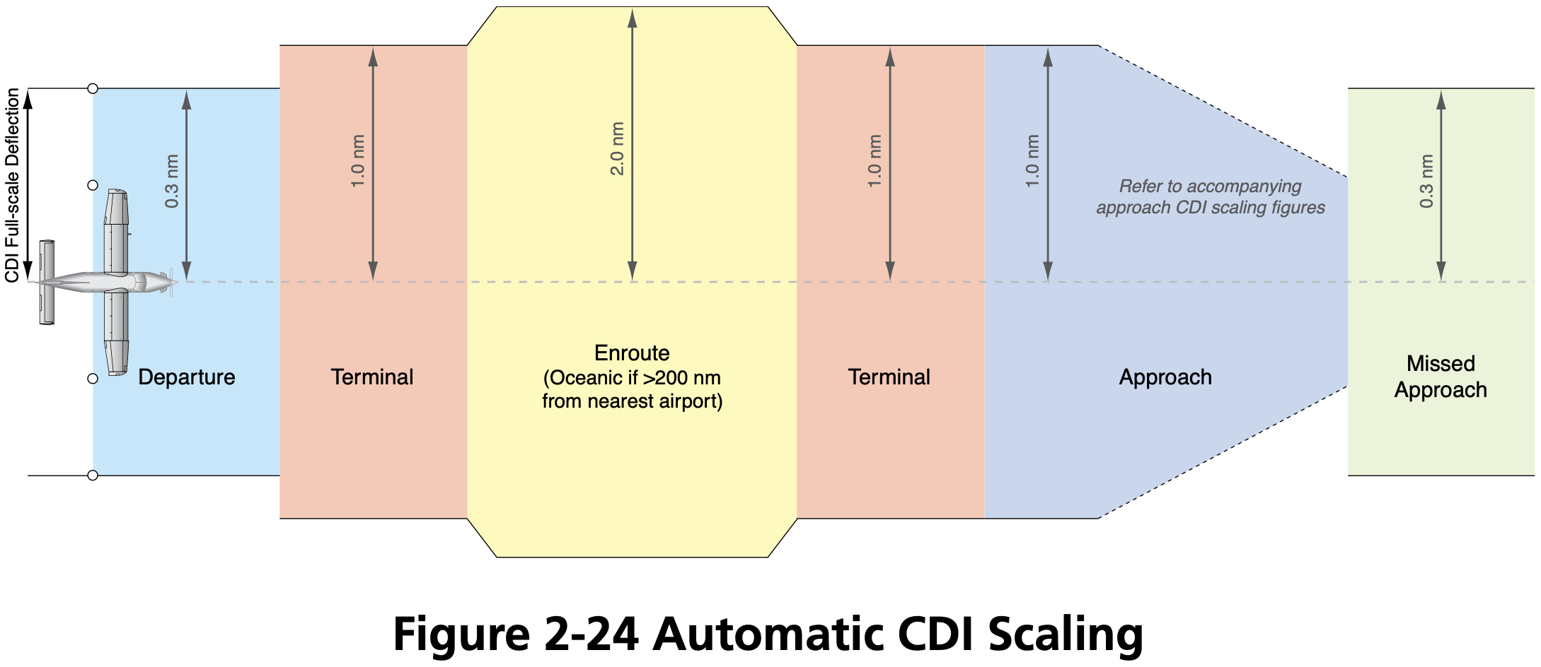
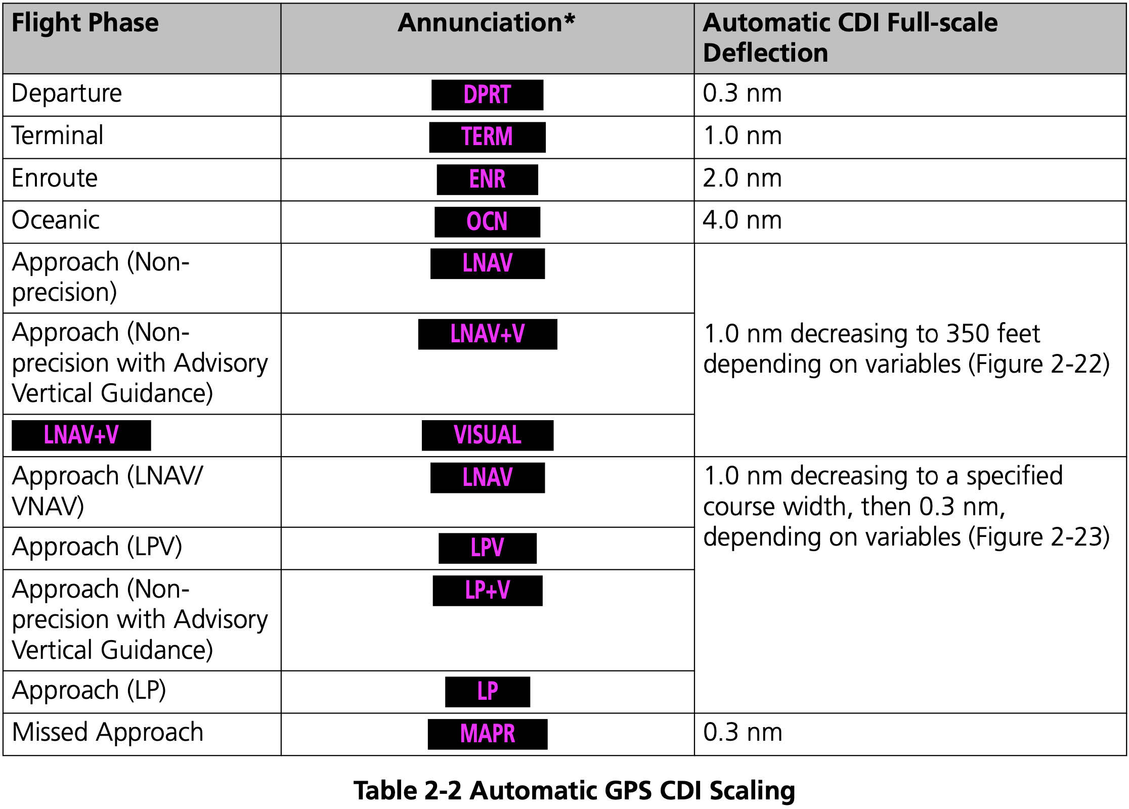
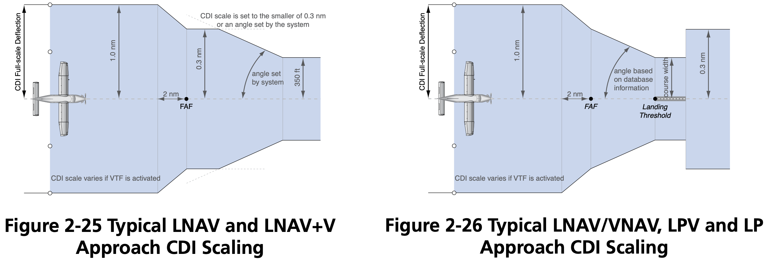
GPS Sensitivity Modes
- Three GPS modes
- Enroute
- More than 30 miles from departure/destination
- 2 nm full-scale deflection
- Terminal
- Within 30 nm of departure/destination
- 1 nm full-scale deflection
- Approach
- 2 nm before final approach waypoint (FAWP) aka final approach fix (FAF)
- 0.3 nm full-scale deflection
- This approximates the sensitivity of a VOR or Localizer approach if located on the field
- Enroute
GPS Routes
- See AIM 5-3-4
- Q Routes: from 1,200 up to but not including 18,000' MSL
- T Routes: from 18,000 up to FL450
- GPS MEA, e.g.
2900G - Airway width is 4 nm on each side of centerline
- Jet routes
- Start with letter J
- From 18,000 up to FL450
- Have no specified width
Regulations
- Technical Standard Orders (TSO) are the regulations that describe GNSS certification
- Three primary categories
- TSO-C129 / TSO-C196
- Non-WAAS GPS systems
- TSO-C196 seems to be an improved version of TSO-C129
- TSO−C145 / TSO−C146
- WAAS GPS systems
- Uncertified
- VFR-only GPS for advisory / situational awareness
- See AIM Table 1-1-6
- May be used for reference
- May not be used for navigation or approaches
- TSO-C129 / TSO-C196
- Check the AFM or AFM supplement that accompanies the GPS installation that will state whether it is approved for IFR, and under what regulations.
- FAA-AC-20-138D
- Describes certification of GPS
- FAA-AC-20-138D

Non-WAAS GPS
Also called non-augmented GPS
May be used as primary source of navigation if the aircraft has working conventional navigation equipment (e.g. VOR receiver)
Use of a suitable RNAV system as an Alternate Means of Navigation when a VOR, DME, VORTAC, VOR/DME, TACAN, NDB, or compass locator facility including locator outer marker and locator middle marker is operational and the respective aircraft is equipped with operational navigation equipment that is compatible with conventional navaids. For example, if equipped with a suitable RNAV system, a pilot may fly a procedure or route based on operational VOR using that RNAV system without monitoring the VOR.
However, RAIM must be available and working to use GPS as a primary source of navigation
Operators planning to use TSO-C129 equipment as a substitute means of navigation must perform a RAIM prediction during preflight. GPS RAIM availability must be confirmed for the applicable operation and time using current GPS satellite information.
For all RNAV systems, substitute and alternate means of navigation must be discontinued upon loss of integrity (for example, RAIM alert) or unacceptable degradation of system performance.
GPS can be used in lieu of VOR/DME/ADF etc.
- FAA-AC-90-108
- Stated exception is substituting for lateral guidance on final approach course which is discussed in AIM 1-2-3(c) Note 5
- This includes over 24,000 feet requirement to have DME
- FAA-AC-90-108
When selecting an alternate airport for an IFR flight plan, the alternate must have a non-GPS approach that the aircraft is equipped to fly.
For the purposes of flight planning, any required alternate airport must have an available instrument approach procedure that does not require the use of GPS.
This restriction does not apply to RNAV systems using TSO-C145/-C146 WAAS equipment.
However, if the GPS unit has RAIM, and a RAIM check is performed, then an alternate with only a GPS approach can be used, but only if the destination has an approach other than GPS that the aircraft is equipped to fly.
For flight planning purposes, TSO-C129() and TSO-C196() equipped users (GPS users) ... may file based on a GPS-based IAP at either the destination or the alternate airport, but not at both locations.
TIP
Basically, if you are using a non-WAAS GPS, you must make sure RAIM is available and working before using the GPS under IFR.
Receiver autonomous integrity monitoring (RAIM)
RAIM
Receiver autonomous integrity monitoring (RAIM) is a technology for a GPS unit to assess the integrity of GPS signals it receives to make sure they are correct. AIM 1-1-17(a)(3)
RAIM requires a minimum of 5 satellites, or 4 satellites and barometric altimeter input (baro-aiding), to detect an integrity anomaly. Baro-aiding is a method of augmenting the GPS integrity solution by using a non-satellite input source in lieu of the fifth satellite. Some GPS receivers also have a RAIM capability, called fault detection and exclusion (FDE), that excludes a failed satellite from the position solution; GPS receivers capable of FDE require 6 satellites or 5 satellites with baro-aiding.
See also FAA-AC-90-100A U.S Terminal and En Route Area Navigation (RNAV) Operations
Regarding RAIM failure during a GPS approach AIM 1-1-17(b)(5)(g)(6):
If a RAIM failure/status annunciation occurs prior to the final approach waypoint (FAWP), the approach should not be completed since GPS no longer provides the required integrity. The receiver performs a RAIM prediction by 2 NM prior to the FAWP to ensure that RAIM is available as a condition for entering the approach mode. The pilot should ensure the receiver has sequenced from “Armed” to “Approach” prior to the FAWP (normally occurs 2 NM prior). Failure to sequence may be an indication of the detection of a satellite anomaly, failure to arm the receiver (if required), or other problems which preclude flying the approach.
Checking RAIM
There are several ways to check RAIM, the most common by using the SAPT tool online, or using the GPS receivers built-in RAIM prediction functionality
During the pre-flight planning phase RAIM prediction must be performed if TSO-C129() equipment is used to solely satisfy the RNAV and RNP requirement. GPS RAIM availability must be confirmed for the intended route of flight (route and time) using current GPS satellite information.
Operators may satisfy the predictive RAIM requirement through any one of the following methods: ... 2. Operators may use the Service Availability Prediction Tool (SAPT) on the FAA en route and terminal RAIM prediction website; ... 5. Operators may use the receiver's installed RAIM prediction capability
See RAIM Service Availability Prediction Tool (SAPT) Summary Page
Foreflight gives RAIM prediction in the Navlog section.
GPS NOTAMs
- FAA FNS NOTAM Seach
- ForeFlight briefing
Wide-Area Augmentation System (WAAS)
SBAS
Satellite Based Augmentation System (SBAS) augments GNSS with additional ground stations/enhanced information transmitted from satellites for improved accuracy and reliability.
WAAS
Wide-Area Augmentation System (WAAS) is the US implementation of SBAS.
Other SBAS implementations include
- EGNOS - Europe
- MSAS - Japan
- SDCM - Russia
- GAGAN - India
WAAS accuracy can achieve position accuracy of approximately 25 ft 95% of the time.
Enables certain GPS approaches to be performed to lower minimums than otherwise allowed with a non-WAAS GPS (e.g. LPV)
WAAS works by using ground stations at known locations to determine their GPS-measured location
Based on the difference between their known location and measured location a correction message is sent up to some WAAS satellites in geostationary orbit
These corrections are then sent from the WAAS satellites to WAAS-capable GPS receivers
- There are currently 3 such WAAS satellites
If WAAS is working then do not need to be concerned with RAIM
If TSO-C145/C146 equipment is used to satisfy the RNAV and RNP requirement, the pilot/operator need not perform the prediction if WAAS coverage is confirmed to be available along the entire route of flight.
In the Piper Archer POH (VB-2749) page 2-8:
In areas where GPS WAAS SBAS coverage is not available, the pilot must verify RAIM availability.
Regarding checking WAAS in the Piper Archer POH (VB-2749) page 2-8:
For information on using the WFDE Prediction Program, refer to Garmin WAAS FDE Prediction Program, part number 190-00643, 'WFDE Prediction Program Instructions'.
May be used as primary source of navigation without any other equipment requirements imposed on the aircraft
Unlike TSO-C129 avionics, which were certified as a supplement to other means of navigation, WAAS avionics are evaluated without reliance on other navigation systems. As such, installation of WAAS avionics does not require the aircraft to have other equipment appropriate to the route to be flown.
When using WAAS, alternate airport need only have a GPS approach
For the purposes of flight planning, any required alternate airport must have an available instrument approach procedure that does not require the use of GPS. ... This restriction does not apply to RNAV systems using TSO-C145/-C146 WAAS equipment.
Pilots with WAAS receivers may flight plan to use any instrument approach procedure authorized for use with their WAAS avionics as the planned approach at a required alternate, with the following restrictions. When using WAAS at an alternate airport, flight planning must be based on flying the RNAV (GPS) LNAV or circling minima line, or minima on a GPS approach procedure, or conventional approach procedure with “or GPS” in the title.
Checking WAAS Availability
- The William J. Hughes Technical Center WAAS Test Team website seems to be the best resource for checking WAAS availability
- The Airport Schedules application seems to be the easiest way to determine WAAS availability
Determining GPS Receiver Capabilities
Check AFM/POH
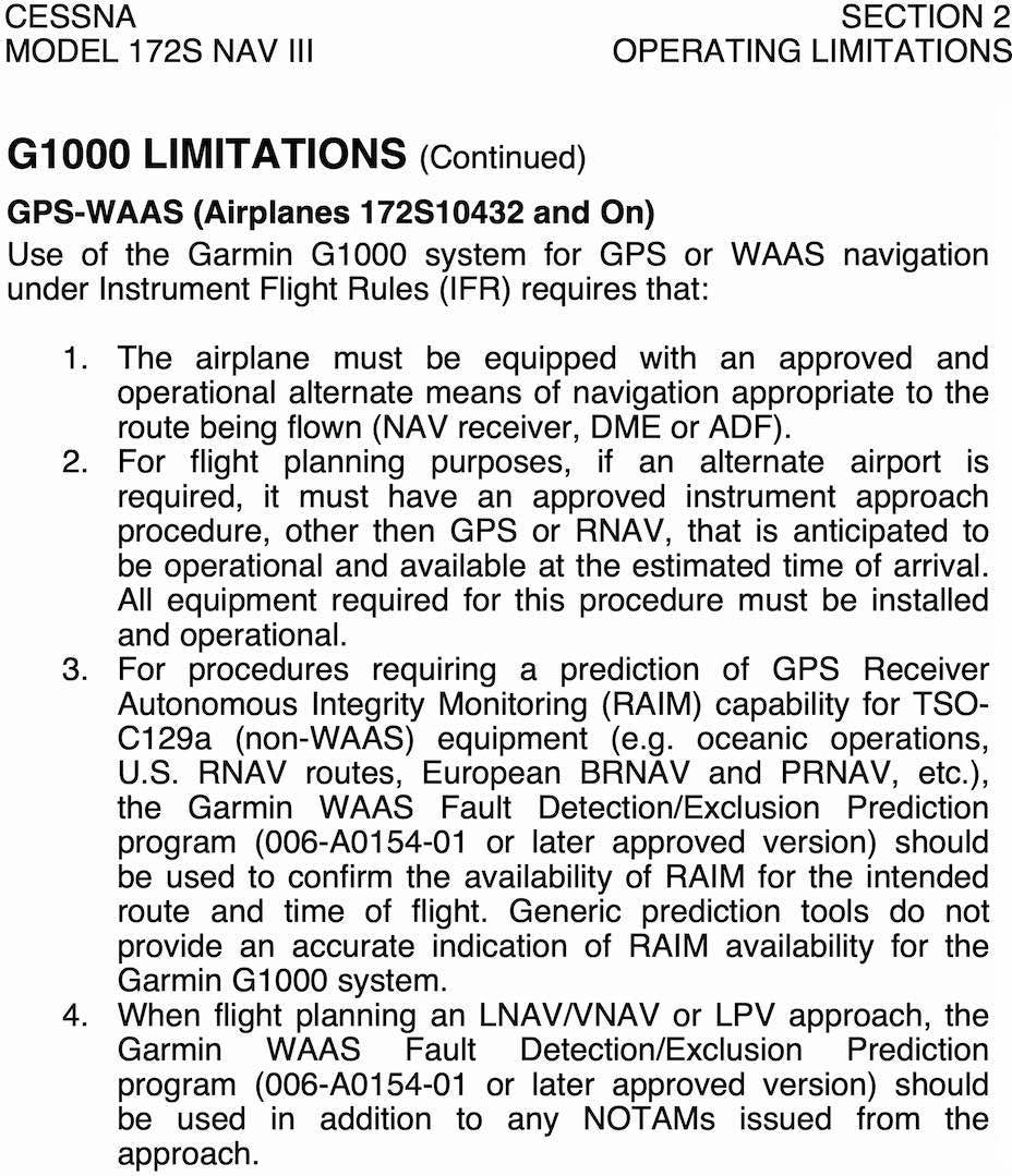
- See, for example on a Cessna 172S G1000, the POH Section 2 - G1000 LIMITATIONS - GPS-WAAS for more info.
- In the Garmin G1000 NXi Pilot's Guide for the PA-28-181 Archer see the System Overview section
Check aircraft receiver
In the Garmin G1000 NXi Pilot's Guide for the PA-28-181 Archer it describes the PRN (pseudo-random noise, the unique ID identifying the satellite) and signal strength bars
As the GPS receiver locks onto satellites, a signal strength bar is displayed for each satellite in view, with the appropriate satellite PRN number (01-32 or 120-138 for WAAS) below each bar.
The signal strength bars are described on page 20, but a solid green bar means the satellite is being used
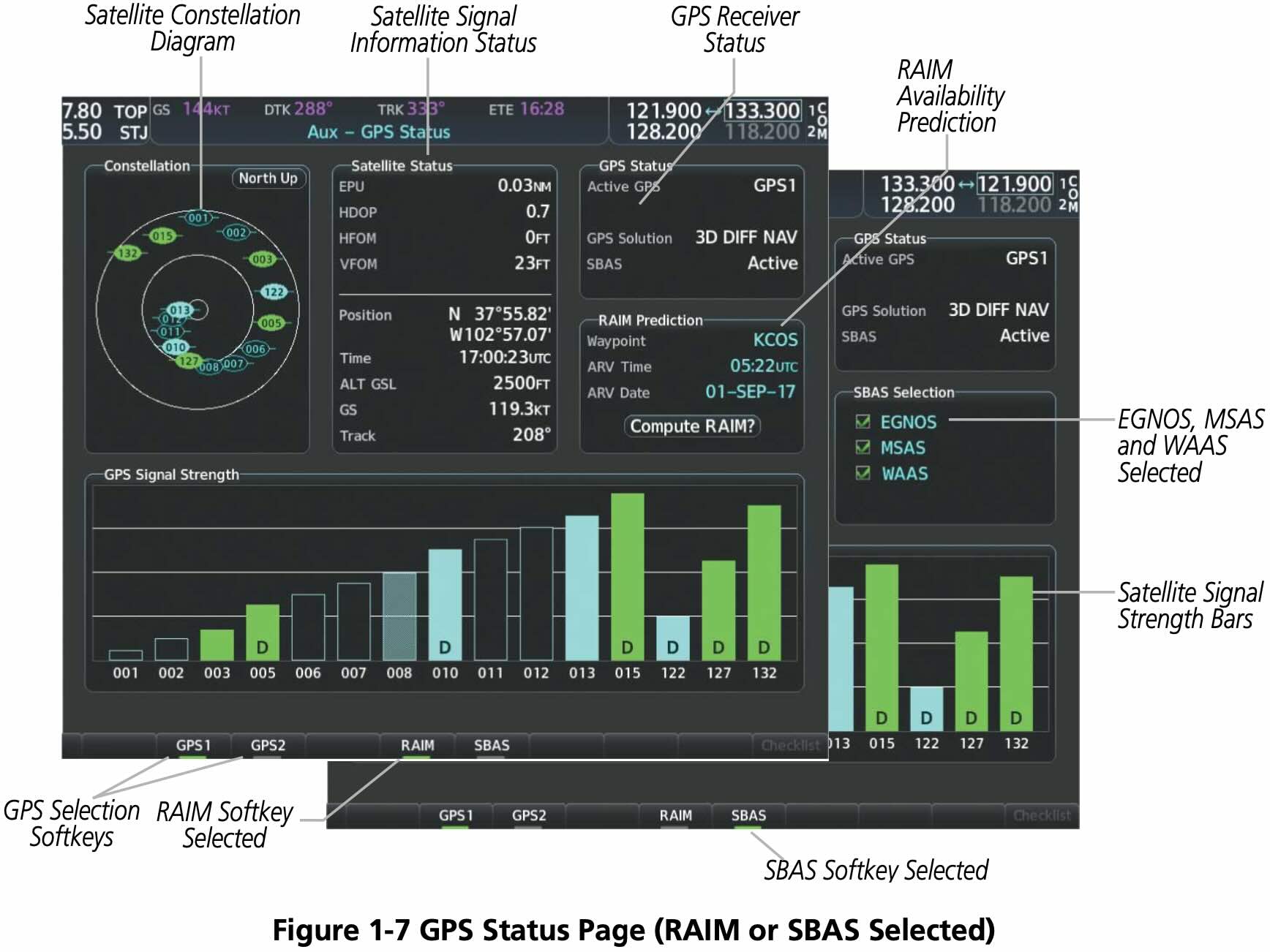
- WAAS satellite PRN 138 was decommissioned in May 2022 and replaced by PRN 135
Using GPS During IFR Operations
- Verify database is current
- See the exception in AIM Table 1-1-6 that allows flying with an expired GPS database
- Verifying approaches haven't changed or been amended
- Verifying route hasn't changed
- See the exception in AIM Table 1-1-6 that allows flying with an expired GPS database
- Check RAIM or WAAS
Using GPS for Non-GPS Approaches
GPS can be used in lieu of a VOR for a VOR approach if the underlying NAVAID is monitored for final approach segment coarse alignment
AIM 1-2-3(c) Note 5
Use of a suitable RNAV system as a means to navigate on the final approach segment of an instrument approach procedure based on a VOR, TACAN or NDB signal, is allowable. The underlying NAVAID must be operational and the NAVAID monitored for final segment course alignment.
If a DME fix on a Localizer approach isn't in the GPS database you may only define that fix using GPS distance from the localizer antenna
TIP
To satisfy the requirement that the NAVAID underlying frequency be monitored on the final approach course, tune the VOR use the bearing pointers, and ensure they align with guidance provided by GPS.
GPS Failures
- On the G1000, the GPS flight phase (e.g.
ENR,TERM,LPV) is shown on the HSI to the right of the CDI - Normally this text is magenta
- If cautionary conditions exist this text will be in amber
- the
LOI(Loss of Integrity Monitoring) indication appears to the right of the HSI when GPS integrity is insufficient for the current phase of flight
Airframe Icing
- For ice to form need
- Visible moisture
- Surface temperatures freezing or below
- Often occurs when outside temperatures are between -20 and 5 °C
- Typically forms on wing and propellor
- Clear ice
- Most dangerous
- Happens when flying through rain
- Most rapid ice formation
- Typically forms in cumuliform clouds
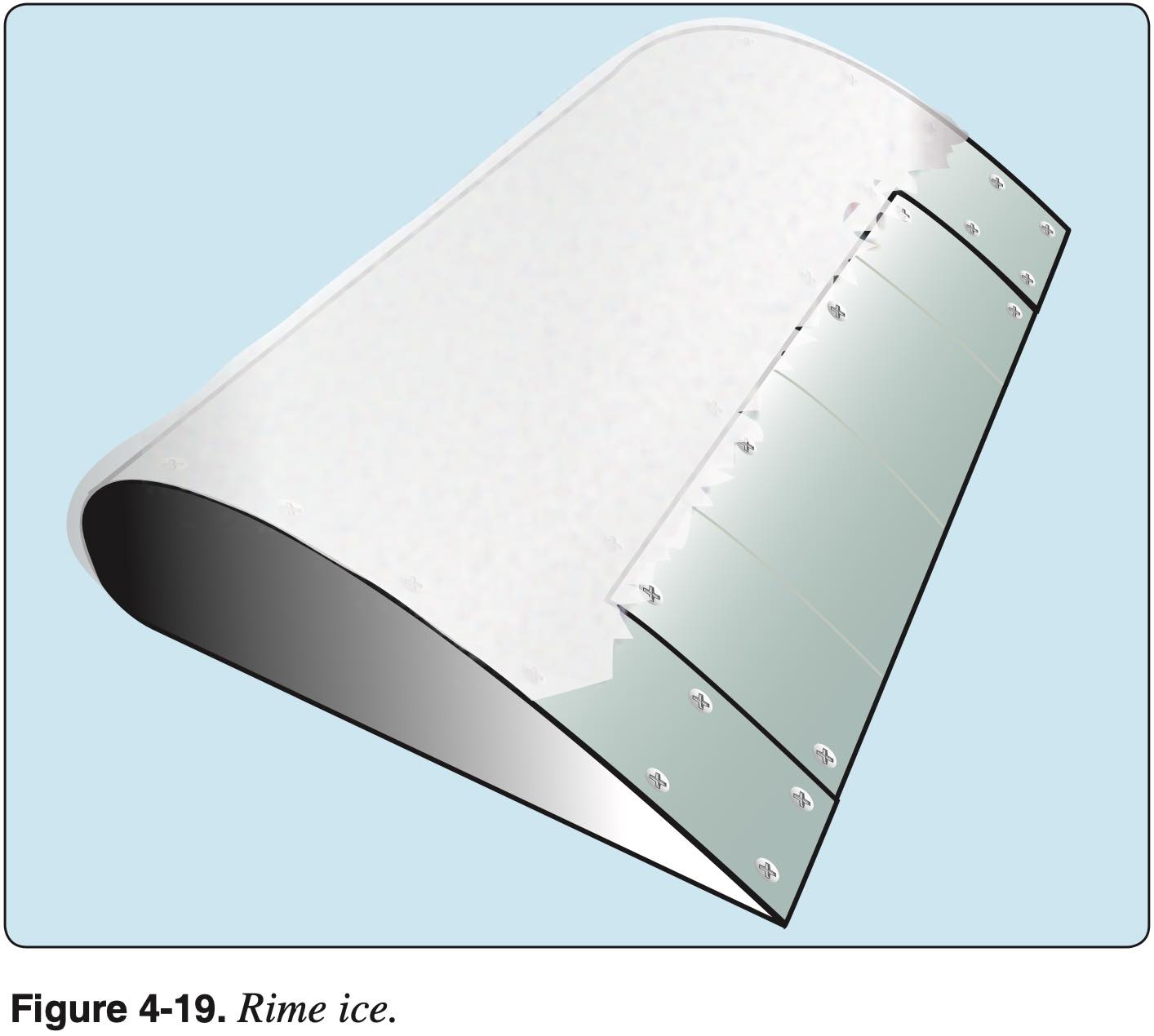
- Rime ice
- Happens when flying through clouds
- Mixed ice
- Has the properties of both clear and rime icing
- Large and small supercooled droplets coexist
- Appearance is whitish, irregular and rough
- Frost
- Aircraft surface temperature and dew point both below freezing
- Freezing rain
- Rain falling from warmer air into air that is colder than freezing
- Ice pellets indicates there is freezing rain above
Adverse Effects of Airframe Icing
- Disturbed airflow over wings and other surfaces
- More drag
- Less lift
- Reduces stall angle-of-attack
- Adds weight
Deicing and Anti-icing
Airframe
- Wings
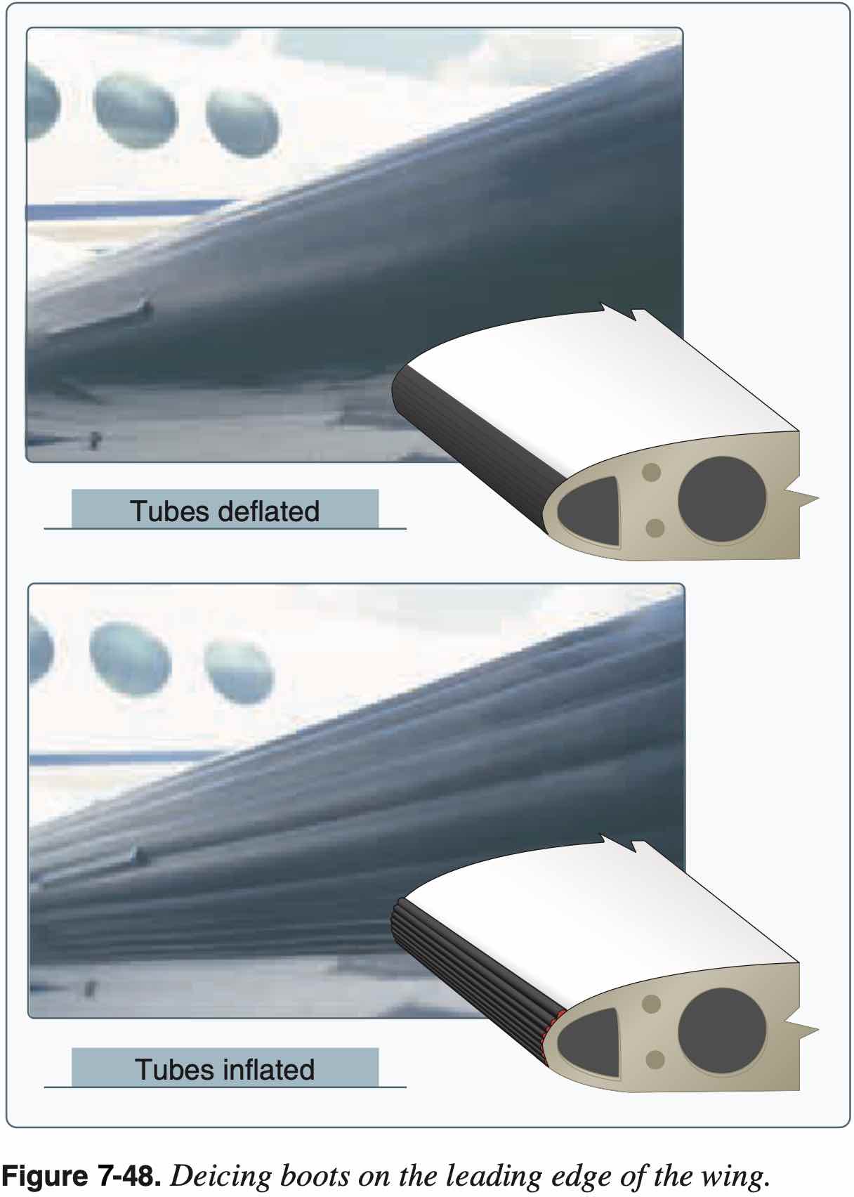
- Boots
- Use as soon as icing is observed
- Heated leading edge
- Also called "hot wing"
- Uses hot air from turbine compressor, for example
- Weeping wing
- Deicing fluid (e.g. TKS fluid, like antifreeze) comes out of small holes in leading edge
- TKS (Tecalemit-Kilfrost-Sheepbridge Stokes) was the name of a British aerospace company during WWII that developed the original weeping wing technology
- Boots
- Windscreen
- Alcohol
- Hot air defrost
- Electric (like rear window of car)
- Icing fluid from prop in single engine also sprays back on windscreen

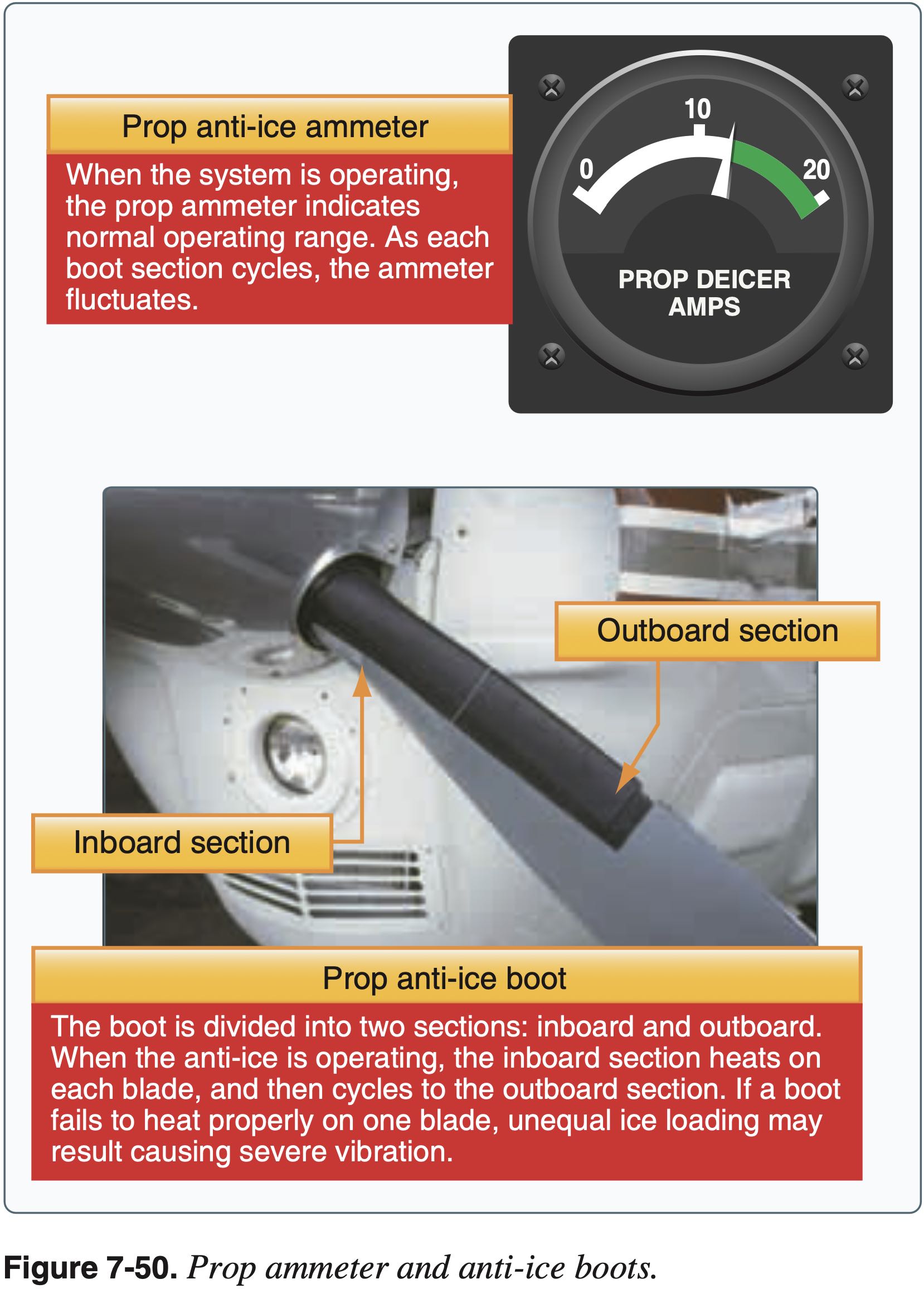
Propellor or Rotor
- Propellor
- Alcohol
- Electric heating element
- Boots
Air Intake
- Carb heat
- Spring-loaded air-filter bypass door
- Alternate air
Fuel System
- Check for water in fuel during preflight
Pitot-Static System
- Pitot heat
- Alternate static source
Encountering Icing
- Exit area of icing
- Generally climb
- To find temps colder than -20 °C
- Being higher gives more options
- Alternatively descend to find temperatures warmer than 5 °C
- Gentle maneuvers
- Avoid increasing load factor too much
- Fly faster
- Avoid configuration change
- No flaps to avoid tailplane stall
Icing Regulations
Known icing conditions
- Note: Part 91 was updated since this letter to include 14 CFR §91.527
"Known icing conditions" involve instead circumstances where a reasonable pilot would expect a substantial likelihood of ice formation on the aircraft based upon all information available to that pilot.
Whether a pilot has operated into known icing conditions contrary to any limitation will depend upon the total information available to the pilot, and his or her proper analysis of that information in evaluating the risk of encountering known icing conditions during a particular operation.
Atmospheric conditions in which the formation of ice is observed or detected in flight. Note-Because of the variability in space and time of atmospheric conditions, the existence of a report of observed icing does not assure the presence or intensity of icing conditions at a later time, nor can a report of no icing assure the absence of icing conditions at a later time.
Altitude Selection
- TBD
Calculations
- TBD
Managing Flight Plan
Filing an IFR Flight Plan
- File flight plan to IAF
- Use time to IAF
- Altitude is initial cruising altitude
- I think this is different than what was in the FAA written?
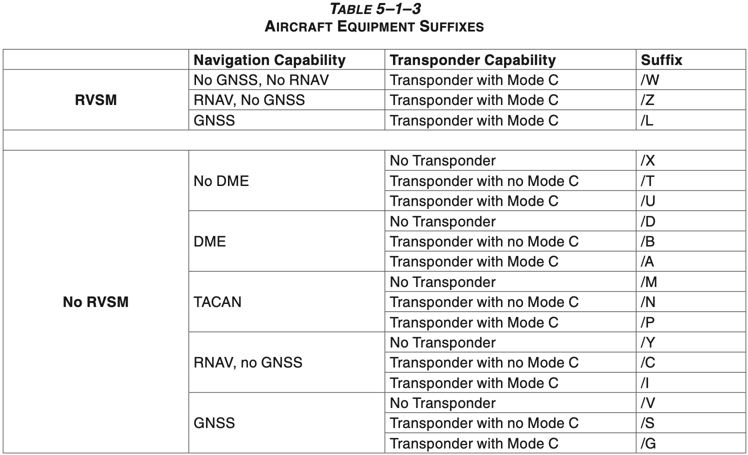
- For aircraft equipment suffixes also see
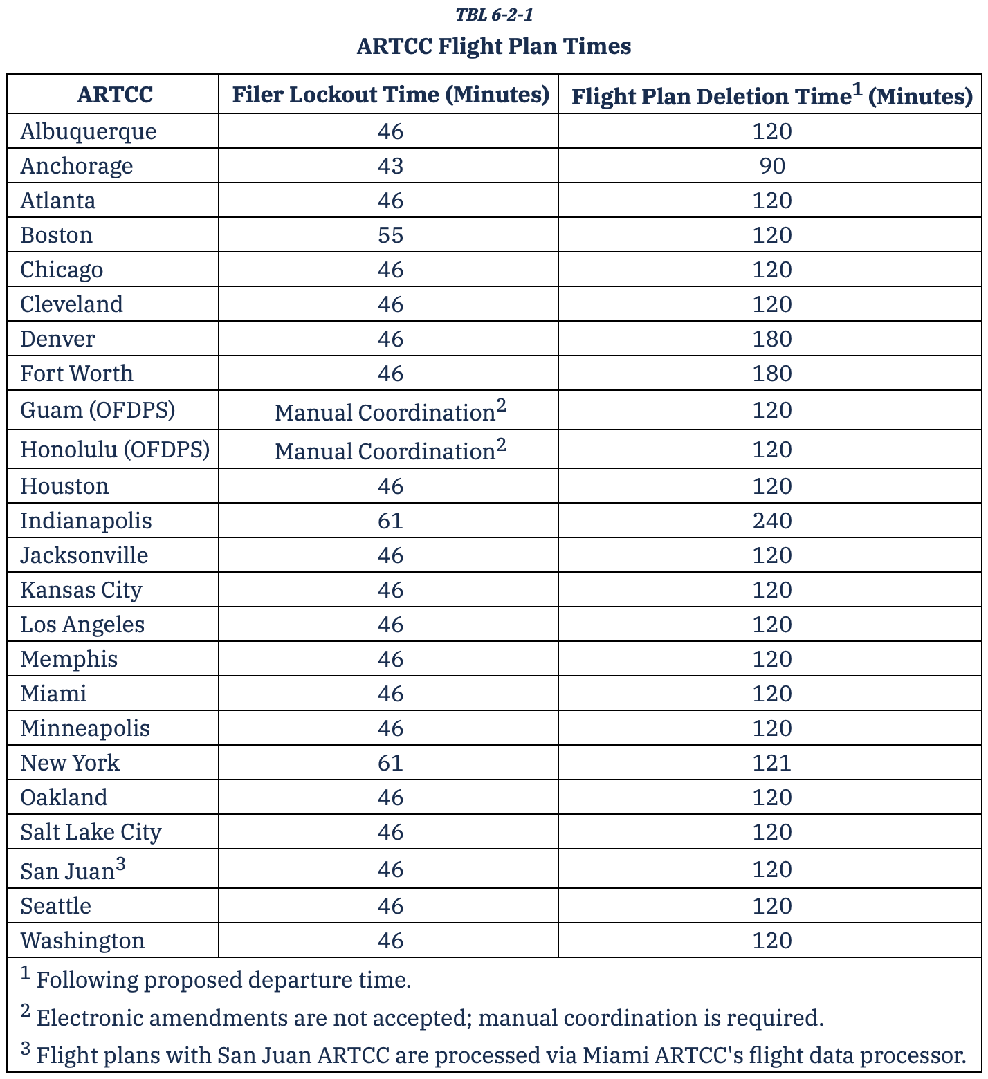
- IFR flight plans remain in system from 30 minutes before ETA to 2 hours after
AIP ENR 1.10 Flight Planning (Restriction, Limitation or Advisory Information) Section 9.1
To prevent computer saturation in the en route environment, parameters have been established to delete proposed departure flight plans which have not been activated. Most centers have this parameter set so as to delete these flight plans a minimum of 2 hours after the proposed departure time or Expect Departure Clearance Time (EDCT). To ensure that a flight plan remains active, pilots whose actual departure time will be delayed 2 hours or more beyond their filed departure time, are requested to notify ATC of their new proposed departure time.
File flight plan at least 30 minutes before ETD
Can file an IFR flight plan up to 22.5 hours before departure time
Flight plan uses true airspeed when filing
VFR flight plans are held for 1 hour after proposed departure time
Have 30 minutes to close VFR flight plan after ETA
If no runway gradient information is specified in the Chart Supplement (formerly called airport facility directory or AF/D) then by definition it is less than 0.3 percent