GPS Approaches
Overview
- GPS is a type of RNAV
- Original RNAV system used multiple VORs and DME to determine location and enable the creation of waypoints and routes
- Non-GPS RNAV is essentially no longer used
- With GPS you can shoot any RNAV approach, e.g.
RNAV (GPS) RWY 33 - Other RNAV systems cannot shoot GPS-only approaches, e.g.
GPS RWY 15 - In practice, RNAV is equivalent to GPS
- Original RNAV system used multiple VORs and DME to determine location and enable the creation of waypoints and routes
- GPS approach use
- GPS MUST have sequenced into approach mode by the final approach waypoint (FAWP) aka FAF
- If not pilot must proceed MAP at the next published altitude higher than the MDA
- In WAAS-equipped planes also make sure the glidepath indicator is shown
- RAIM failure before FAWP (FAF)
- Must go missed
- May not descend to MDA
- See AIM 1-1-17(b)(5)(g)(6) and more in RAIM section below
- RAIM failure after FAWP (FAF)
- Go missed immediately
- GPS MUST have sequenced into approach mode by the final approach waypoint (FAWP) aka FAF
- GPS will give you the lowest minimums it is capable of giving you
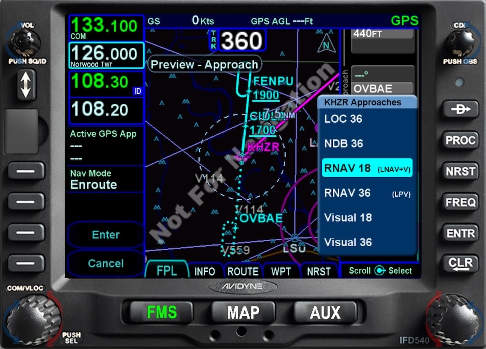
- GPS (LNAV, LPV, etc.)
- If you CAN use LPV minimums, the GPS unit MUST show you "LPV" in the annunciator window.
- It's possible that you're LPV-equipped, but your annunciator window shows you only "LNAV", for example.
- To see WAAS status? FAA William J. Hughes Technical Center WAAS Test Team
GPS Approach Types
LNAV
- Original kind of approaches, basically overlay of existing non-precision approaches like VOR or NDB
- Lateral navigation
- No vertical guidance
APP,APR,LNAVon GPS display- "standard" GPS minimums
- Don't need WAAS
- 0.3 nm (556 m) lateral limit
- With the needle centered, will be within 0.3 nm (556 m) of the final approach course 95% of the time
LP
- GPS equivalent of localizer, more accurate than LNAV, but still no vertical guidance, but falls into WAAS family of approaches
- 0.02 nm (40 m) lateral limit
- With the needle centered, will be within 0.02 nm (40 m) of the final approach course 95% of the time
LNAV/VNAV
- Approach with vertical guidance
- Requires baro-aided altimeter or appropriately certified WAAS GPS
- Typically has minimums that are higher than LPV minimums, but occasionally LNAV/VNAV minimums are below those for LPV
- See below for some specific examples
LPV
- Approach with vertical guidance
- Localizer performance with vertical guidance
- GPS equivalent of ILS
- Same accuracy (width) as a localizer
LPVon GPS display
LNAV+V
- In plane with WAAS-equipped GPS can be provided an advisory glidepath on LNAV non-precision approach to help fly the approach
- Still responsible for adhering to MDA and do not descent below
- Advisory glidepath does not ensure obstacle clearance
GPS overlay approaches
VOR OR GPS RWY 14- Not too common
- If an approach is in the GPS database but is not a GPS approach
- You must fly it with NAV radios
- You may use GPS for reference only
- Exception is NDB approaches
- NDB Approaches
- May be flown solely with GPS if it says
NDB or GPS - Or if you have a working NDB onboard, although you need not monitor it
Magnetic Course Differences
Differences may exist between PBN systems and the charted magnetic courses on ground-based NAVAID instrument flight procedures (IFP), enroute charts, approach charts, and Standard Instrument Departure/Standard Terminal Arrival (SID/STAR) charts. These differences are due to the magnetic variance used to calculate the magnetic course.
This paragraph goes on to provide more information about these differences.
Interesting Approaches
Better LNAV/VNAV Minimums
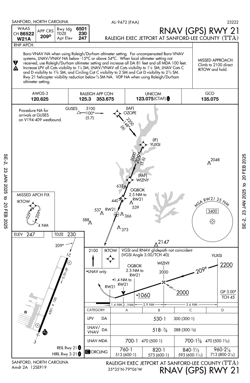
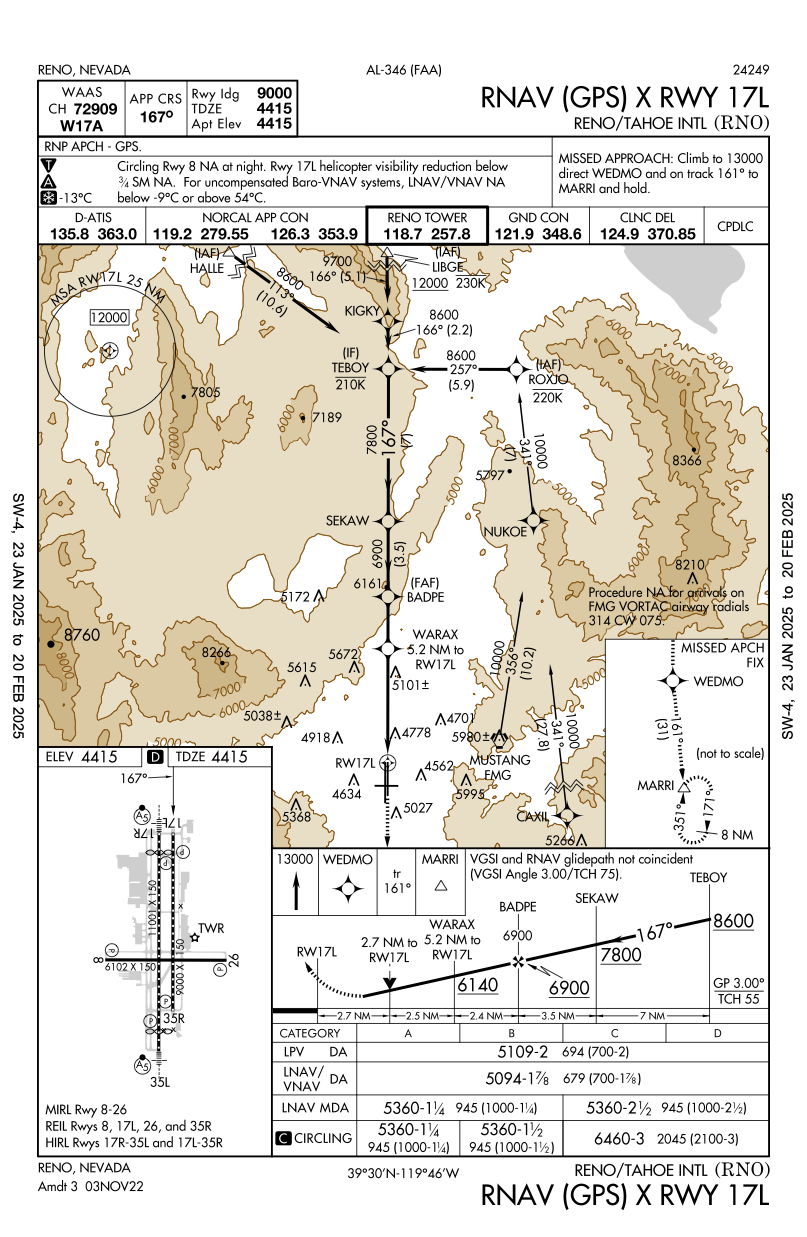
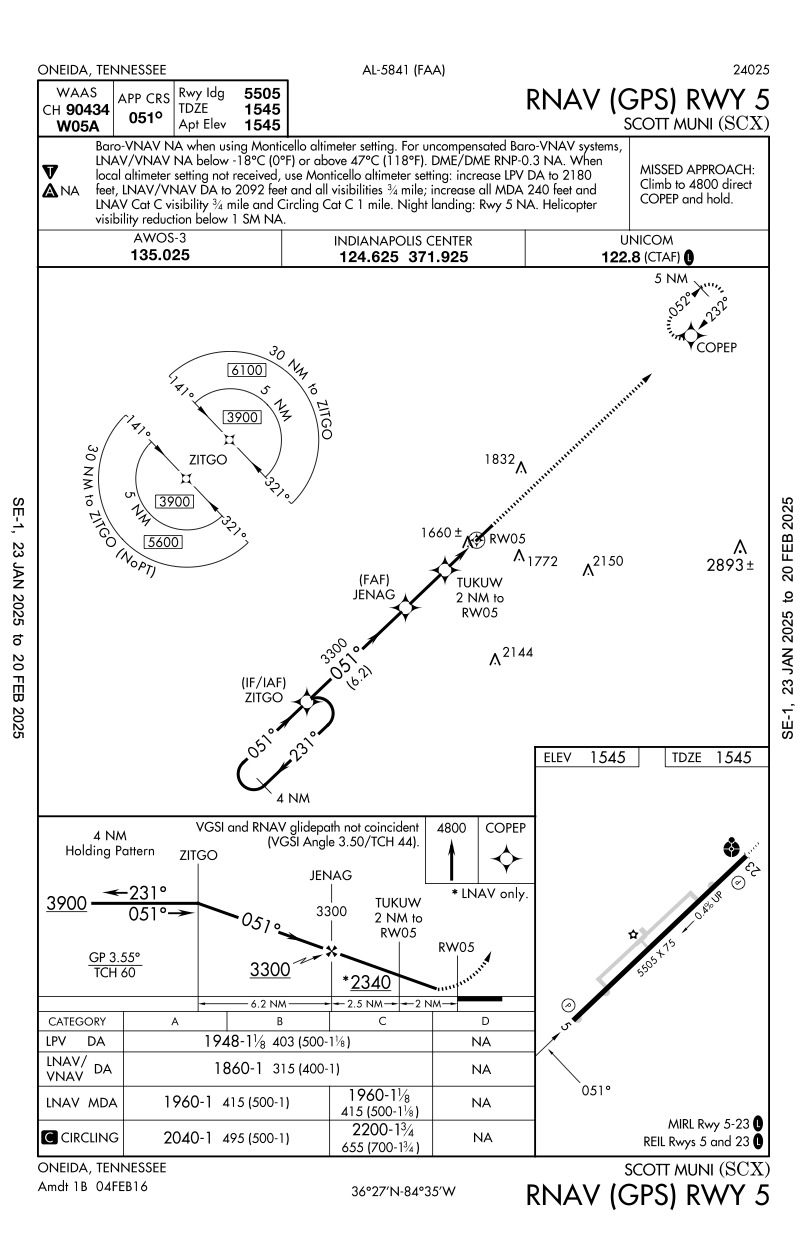
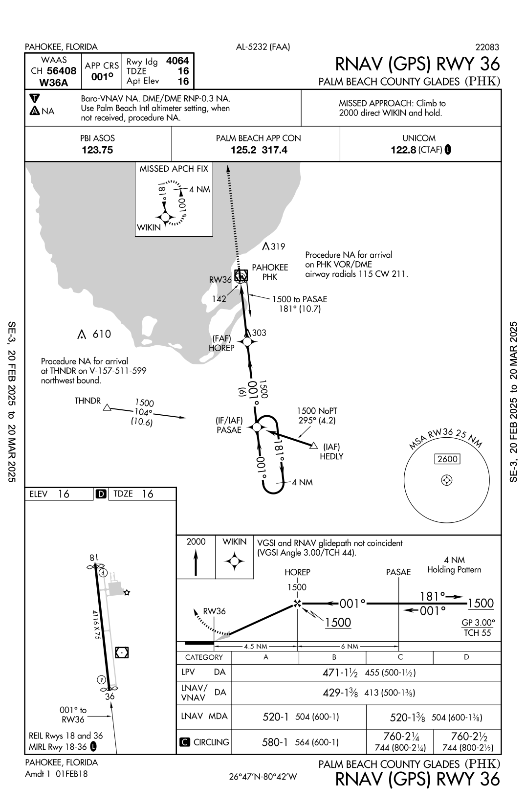
- Approaches where LNAV/VNAV minimums are lower than the corresponding LPV minimums.
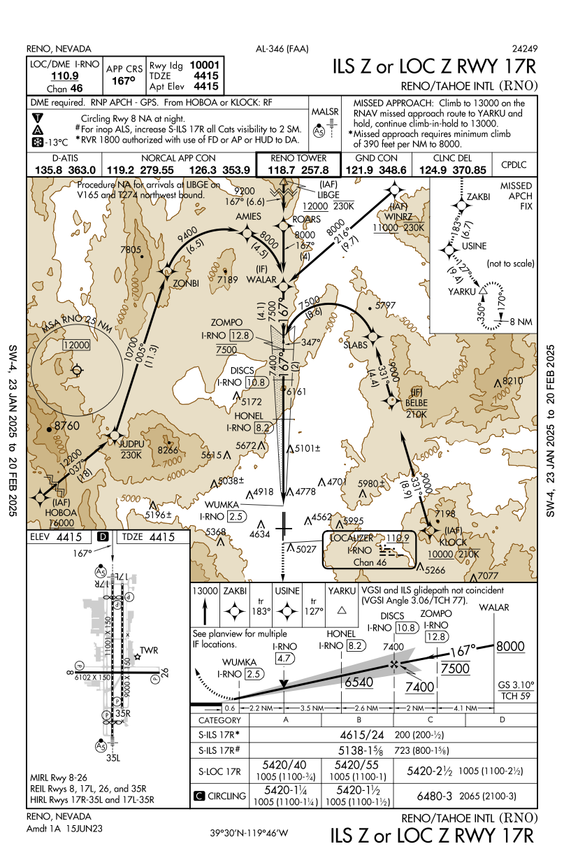
KTTA RNAV (GPS) RWY 21KRNO RNAV (GPS) X RWY 17LKSCX RNAV (GPS) RWY 5KPHK RNAV (GPS) RWY 36KHZR RNAV (GPS) RWY 18
- While LPV does enable lower minimums than LNAV/VNAV, due to some specifics of how the approaches are designed there are cases where LNAV/VNAV minumums end up being lower.

Vertical Guidance Higher Visibility
- Approaches where vertical guidance (provided by LNAV/VNAV) gives a lower DA (than the corresponding LNAV MDA) but requires higher visibility.
KMKO RNAV (GPS) RWY 4PAUT RNAV (GPS) RWY 27


Only LNAV/VNAV Vertical Guidance
- Approaches where only LNAV/VNAV is available for vertical guidance and not LPV.
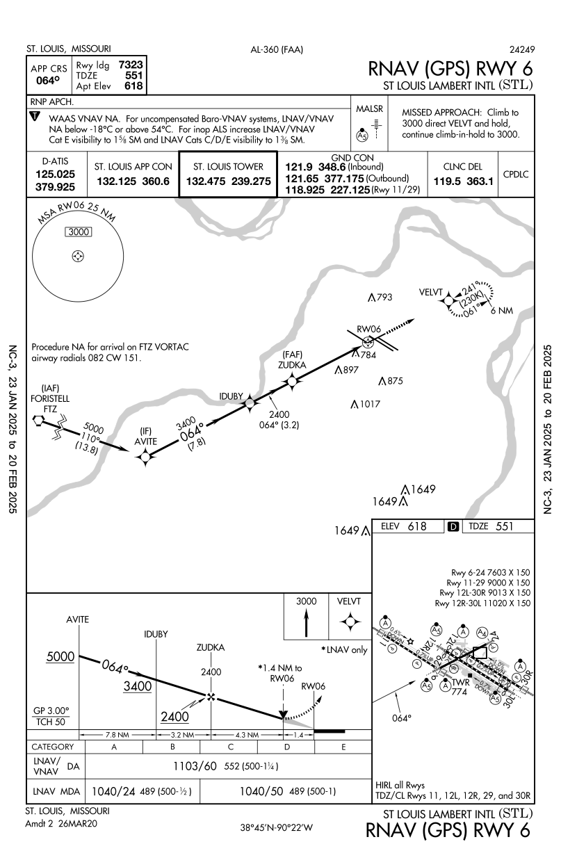
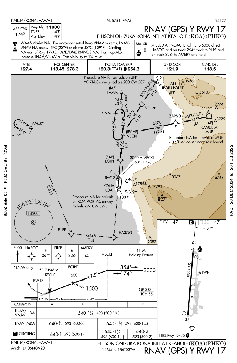
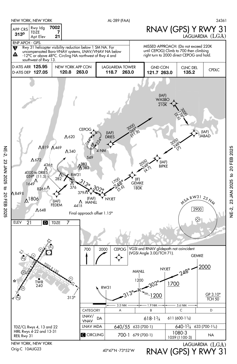
KSTL RNAV (GPS) RWY 6PHKO RNAV (GPS) Y RWY 17KLGA RNAV (GPS) Y RWY 31
- These approaches aren't particularly interesting, but worth reviewing and understanding before flying these appraoches, if the airplane used has the capability to fly LNAV/VNAV.
- In many GA planes this ability is provided by WAAS.
- Always check and understand aircraft capabilities before planning a particular approach.
WAAS Cannot be used for VNAV
- Approaches where WAAS cannot be used for VNAV vertical guidance
TJSJ RNAV (GPS) RWY 10
- This is an interesting case to note in the context of the section above, whereby if the aircraft being used has VNAV capabilities provided only by WAAS, then the VNAV minimum cannot be used.
- If the aircraft has Baro-VNAV, that can be used for vertical guidance

Circling Only GPS Approaches
- Relatively uninteresting, but despite the fact that GPS approaches are not constrained in their design by ground-based navaids, and therefore seems they should always be designed as straight-in approaches, terrain or other factors might constrain them to being circling-only approaches as below.
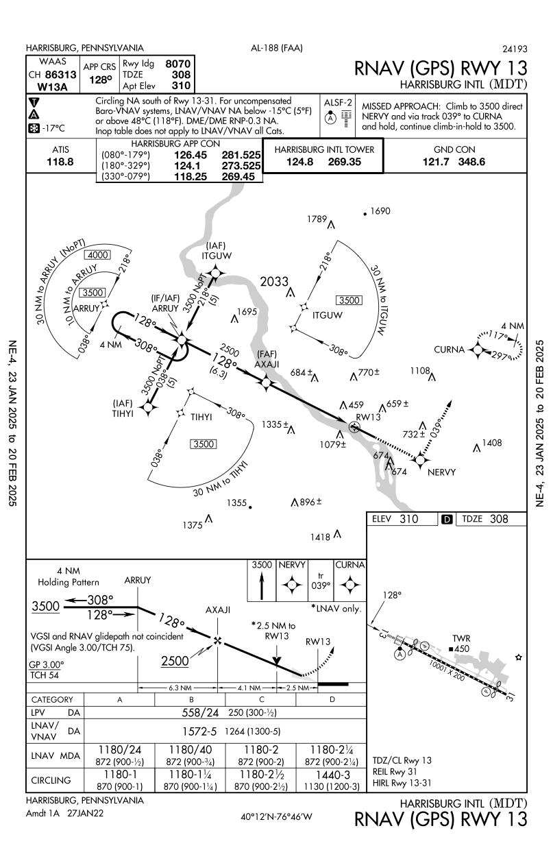
Bad LNAV/VNAV Minimums
- This is an interesting case where the LNAV/VNAV approach (despite providing vertical guidance) are significantly higher than the the other approaches without vertical guidance, including the LNAV only.
KMDT RNAV (GPS) RWY 13- LNAV/VNAV minimums just seem bad relative to other options
Computer Navigation Fix
A computer navigation fix (CNF) is not for use by pilots but is charted nonetheless. See the legend in the terminal procedures publication.
RNP and PBN on Approaches
- On PBN approach minima: FAA Order 8260.58D
- On approach plate definitions: FAA Order 8260.19H.
RNP Equipment Requirements
RNP APCH - GPS, to signify that the RNP APCH requirements must be met using GPS and not some other RNAV method- Reference for this?
- Most other approaches list
RNP APCH - Systems which satisfy RNP requirement without GPS include
- DME/DME/IRU on B757/B767
RNP Required on ILS and Other Approaches
- In these cases
RNP APCH - GPSmay be required, even though final approach course guidance might be ILS, for example
RF Required but no Authorization
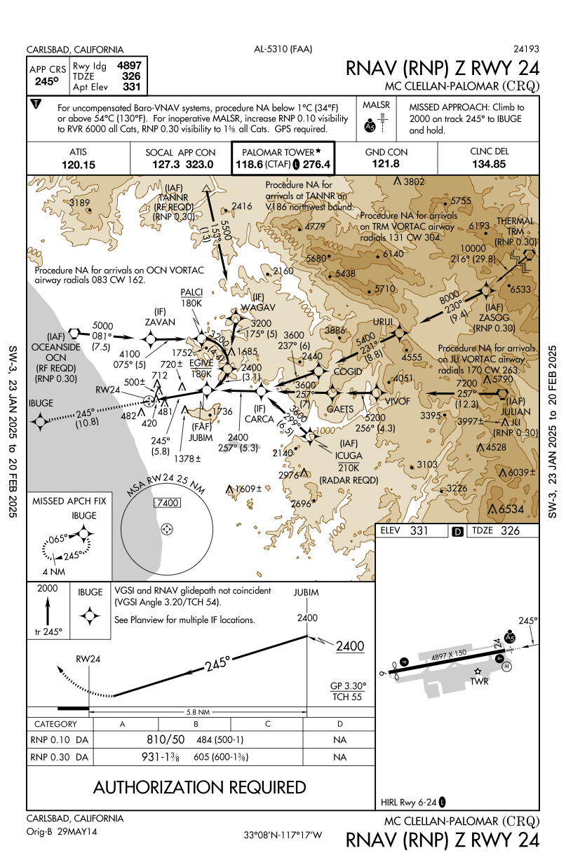
RNP Authorization Required
- The plate will say RNP AR in equipment box and/or be titled
RNAV (RNP)KLAX RNAV (RNP) Z RWY 24RKCRQ RNAV (RNP) Z RWY 24
- See FAA-AC-90-101A
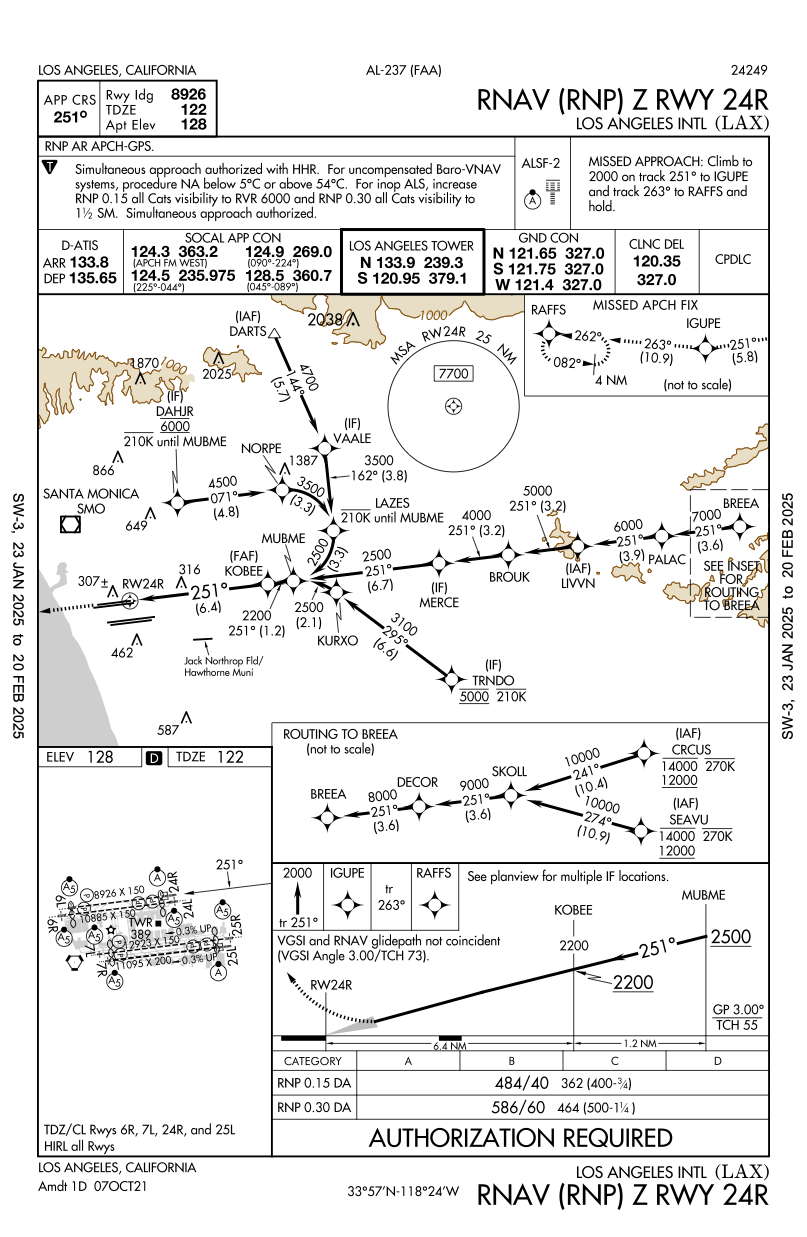
- Why would AR approaches be flown when seemingly better ones exist that don't require authorization?
KLAX RNAV (GPS) Y 25LKLAX RNAV (RNP) Z 25L
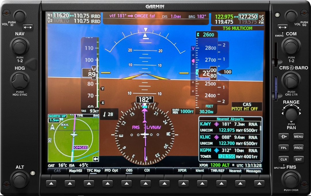
Baro-VNAV
- The Piper Archer with G1000 NXi, as an example, uses SBAS (WAAS) as its primary method of vertical navigation
- Certain approaches such as the
TJSJ RNAV (GPS) RWY 10shown above indicates in the notes thatWAAS VNAV NA, indicating in this case that WAAS is not authorized for vertical nagivation. - In the case of the Piper Archer with G1000 NXi, it does have Baro-VNAV which can be used to provide vertical navigation.