Meteorology
This page covers the portion of Task B. Weather Information from the FAA-S-ACS-8C Instrument Rating Airplane Airman Certification Standards pertaining to weather theory and meteorology.
The Atmosphere
- The atmosphere is approximately (by volume) 78% Nitrogen, 21% Oxygen, and the remaining 1% mostly Argon.
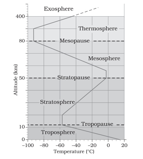
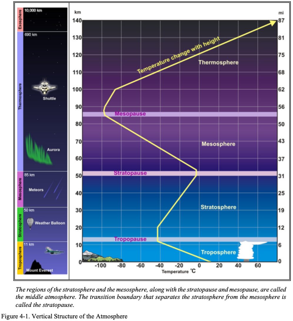
- Earth's atmosphere is divided into several layers.
- The troposphere, which extends up to 36,000 feet is where most flying occurs.
NOTE
Weather is the result of uneven heating and cooling across the Earth. Atmospheric circulation is the movement of air masses in a never-ending persuit of equilibrium.
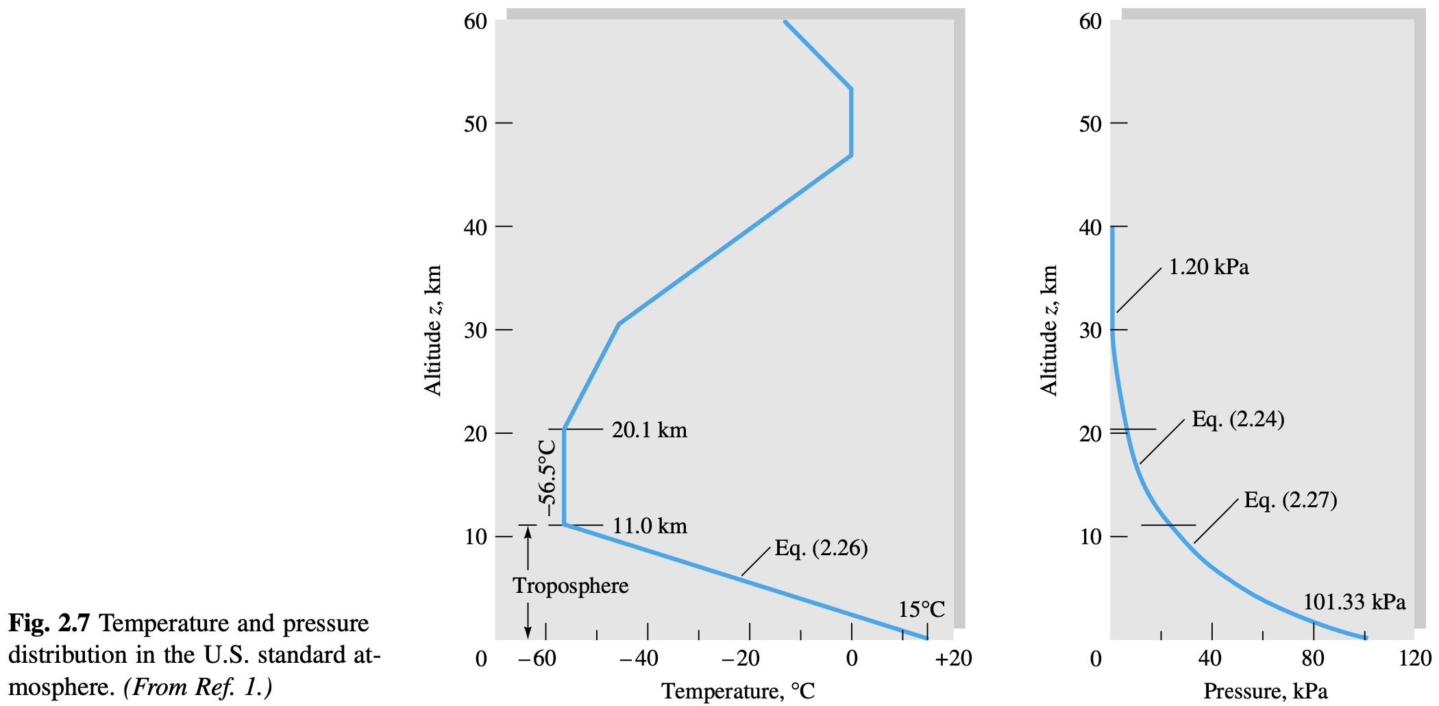
Standard Atmosphere
Standard Atmosphere
The standard atmosphere is a fixed reference standard that represents an average of conditions throughout the atmosphere for all latitudes, seasons, and altitudes.
NOTE
At sea level, standard atmospheric properties are: 59 °F (15 °C), pressure 29.92 inHg (or 1013.2 mb) and no moisture.
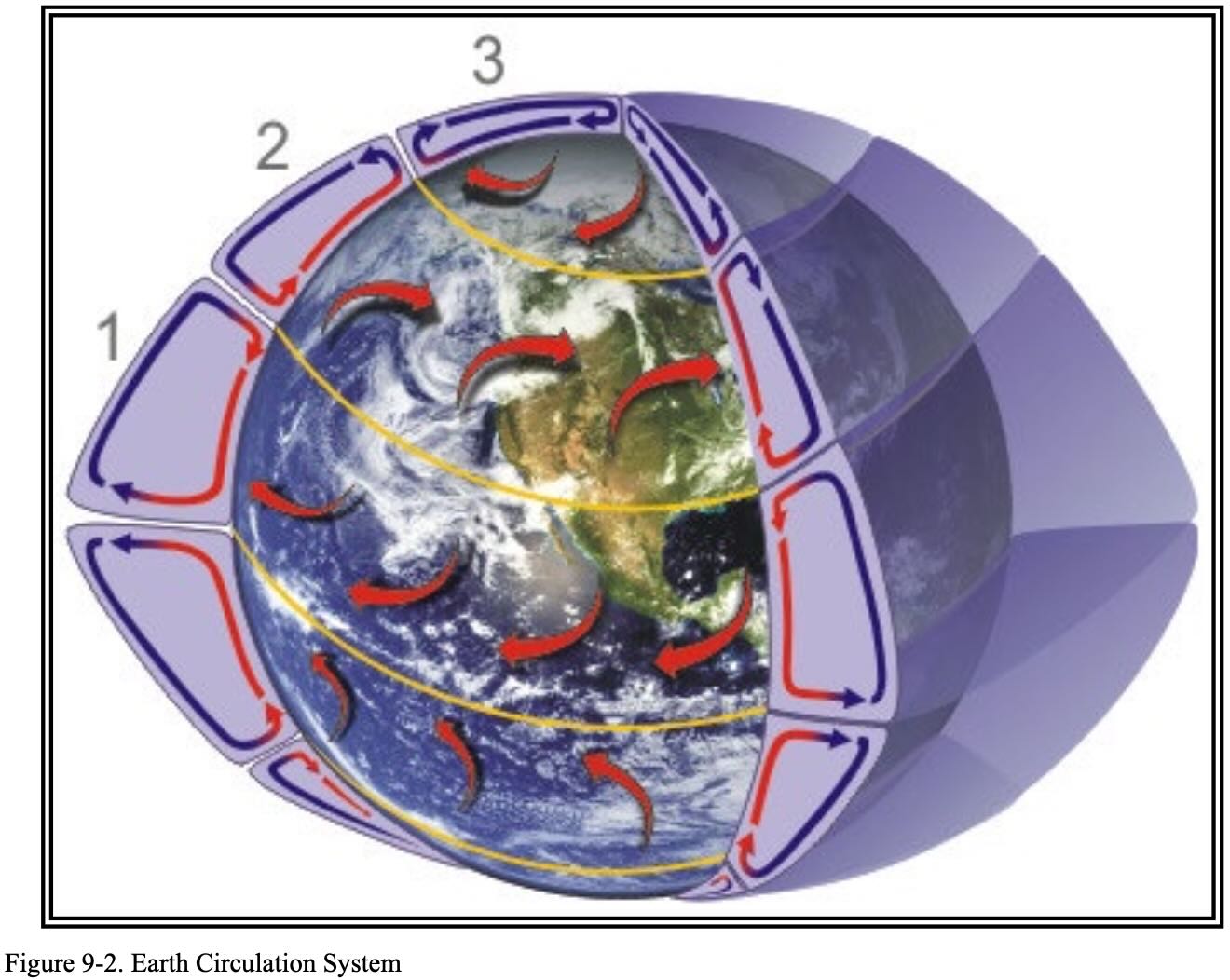
Atmospheric Circulation
- Due to the rotation and tilted axis of the Earth, the circulation pattern of the atmosphere is comprised of the Hadley, Ferrel, and Polar cells.
Pressure Systems
- Low Pressure System (Cyclone)
- Air flows into a low-pressure area to replace rising air. This air usually brings increasing cloudiness and precipitation. Thus, bad weather is commonly associated with areas of low pressure.
- Warm air rises and cold air moves in to replace it.
- Summary
- Inward
- Upward
- Counter clockwise
- Brings bad weather
- High Low Pressure System (Anticyclone)
- Generally areas of dry, descending air. Good weather is typically associated with high-pressure systems for this reason.
- The air is dry because at higher altitudes the air can support less moisture, and because moisture decreases density of the air, so the dense air implies low moisture.
- Summary
- Outward
- Downward
- Clockwise
- Brings good weather
- Generally areas of dry, descending air. Good weather is typically associated with high-pressure systems for this reason.
- Knowing location of pressure systems, along with rotation of air around them, can help plan a faster route cross country by leveraging the tail winds.
- Example: When flying East to West fly just south of high pressure system should help provide good weather and a tailwind.
- Knowing location of pressure systems can also help a pilot avoid bad weather.
- Example: low pressures usually have bad weather, so pilot can avoid low pressure systems.
- Trough: area of low pressure, rising air. Rising air means cloudiness, rain, and bad weather.
- Ridge: area of high pressure. Opposite of trough. Good weather.
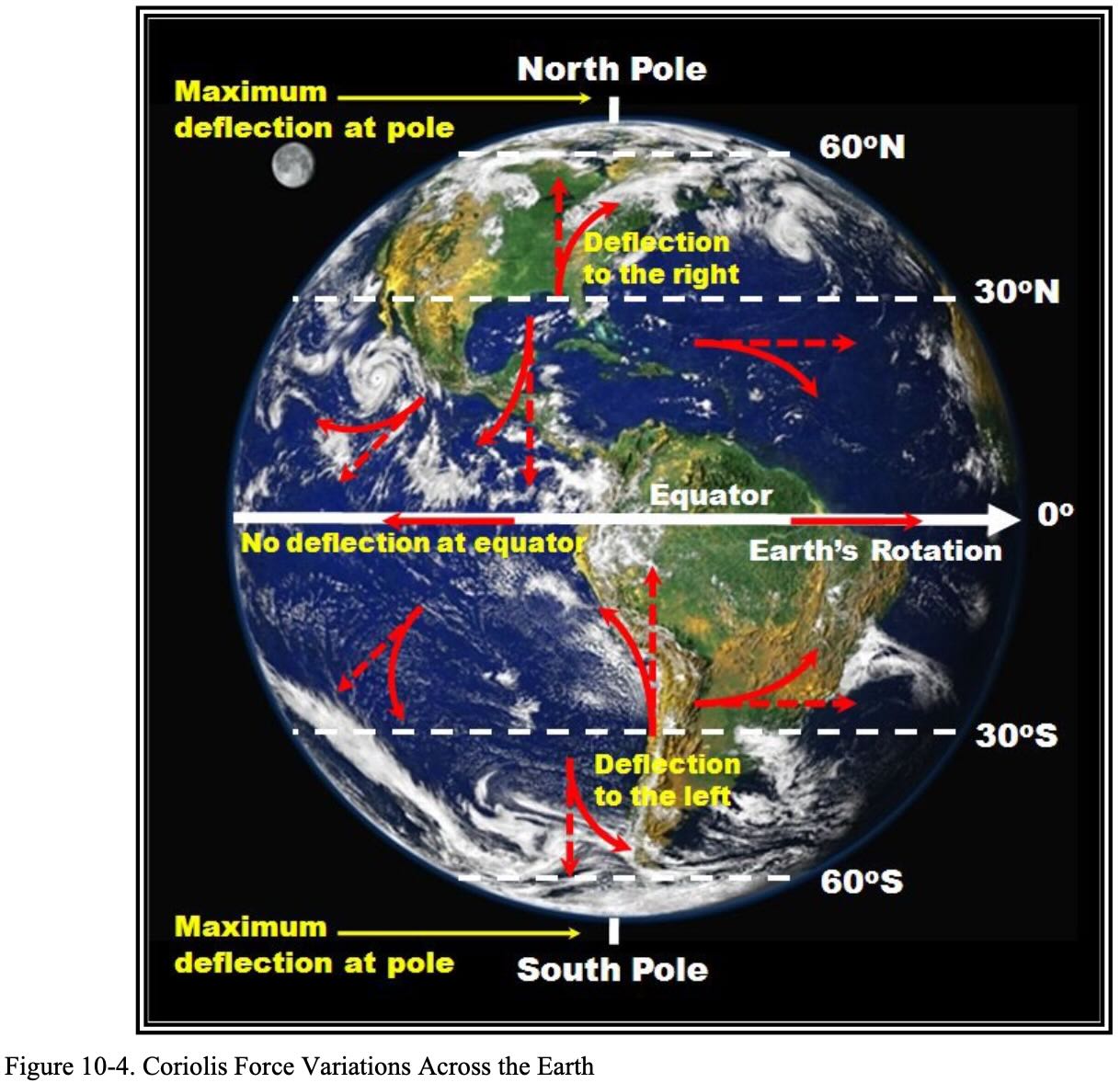
- Coriolis Force
- Deflects wind to the right in the northern hemisphere
- Causes winds aloft to flow parallel to isobars Stability of the atmosphere determines the type and vertical extent of clouds.
- Virga is precipitation trailing beneath clouds but evaporating before it reaches the ground
- Sometimes near virga get strong downdrafts and microbursts
Isobars
- Lines of constant atmospheric pressure
- Ordinarily would expect air to move from high to low pressure
- See: coriolis force and ground friction
- Close to the ground the wind direction is modified by the friction and wind speed decreases and the wind moves from high to low pressure perpendicular to the isobars
- At levels 2,000 to 3,000 feet above the surface, however, the speed is greater and the direction becomes more parallel to the isobars.
- Generally, the wind 2,000 feet AGL is 20 to 40 degrees to the right of surface winds, and the wind speed is greater.
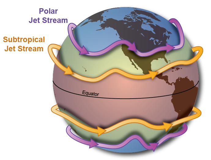
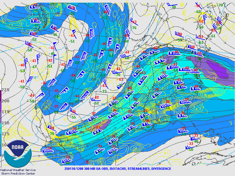
Jetstream
- The jet stream is a band of wind near the upper part of the troposphere that blows from west to east.
- Jetstream is stronger and further south in the winter.
- Speeds up to 250 mph, but average speeds about 110 mph.
- Location of the tropopause is important because it is commonly associated with the location of the jet stream and possible clear air turbulence.
- Associated with jet streams is a phenomenon known as clear-air turbulence (CAT), caused by vertical and horizontal wind shear caused by jet streams. The CAT is strongest on the cold air side of the jet, next to and just under the axis of the jet.
- NOAA: The Jet Stream
Lapse Rates
Lapse Rate
A lapse rate is the rate at which an atmospheric quantity, usually temperature, decreases with altitude.
- Note the implicit sign in the definition above -- a higher lapse rate means larger temperature decreases as altitude increases.
- The standard temperature lapse rate is 3.5 °F (2.0 °C) per 1,000 feet.
- This is for 0 - 36,000 ft
- Above this point, the temperature is considered constant up to 80,000 feet
- The standard pressure lapse rate is 1 inHg per 1,000 ft up to 10,000 feet.
- The dry adiabatic lapse rate is 5.4 °F (3.0 °C) per 1,000 feet.
- This is the rate at which the temperature of a dry parcel of air decreases as it rises in the atmosphere
- The wet adiabatic lapse rate is 3 °F (1.67 °C) per 1,000 feet.
- It varies between 2 to 5 °F (1.1 to 2.8 °C)
- In dry air, dewpoint lapse rate is 1 °F (0.61 °C) per 1,000 feet.
- The temperature and dewpoint converge at about 4.4 °F (2.5 °C) per 1,000 feet.
- Take the dry adiabatic lapse rate (5.4 °F) and subtract dewpoint lapse rate (1 °F)
TIP
Using knowledge of the temperature and dewpoint (as reported on the surface) one can estimate the base of clouds by taking the difference (in °F), dividing by 4.4, and multiplying by 1,000 ft.
Air Masses
Prerequisites
- An adiabatic process is a type of thermodynamic process that occurs without transferring heat or mass between the thermodynamic system and its environment
- The rising and descending of a parcel of atmospheric air is considered adiabatic.
- The mass of the parcel (control volume) is fixed.
- That no heat is exchanged is due to the large volume of such a parcel of air and the timescale of the movement - the timescale associated with the movement of air is much shorter than that associated with heat transfer. In other words, the air doesn't have time to transfer heat as it rises, hence the valid assumption of the process being adiabatic.
- Moist air is less dense than dry air
- Recall atmosphere is 78% Nitrogen (as
) and 21% Oxygen (as ) - Atomic weight of
is 28 g/mol, is 32 g/mol - Atomic weight of
is 18 g/mol - So the presence of water vapor reduces the density of the air mass
- Note: this impacts engine and aerodynamic performance
- Recall atmosphere is 78% Nitrogen (as
- The specific heat capacity of a substance is the amount of heat needed to produce a unit change in its temperature (per unit mass)
- The specific heat capacity of moist air is greater than that of dry air.
- This is due to the presence of water, which has a greater specific heat than air.
- Moist air changes temperature more slowly than dry air.
- This is due to the greater specific heat.
- Land heats faster than water during the day and cools faster at night.
- Its specific heat is less
- Relative humidity - percent of moisture in air versus how much the air can hold
- A rising air parcel does work on surrounding air, so it loses internal energy.
- A rising parcel of air that is less than 100% relative humidity cools at the dry adiabatic lapse rate.
- When the parcel of air becomes saturated (100% relative humidity) some of the energy loss comes from condensing moisture, so
is less than dry parcel. - This is why the moist adiabatic lapse rate is less than the dry adiabatic lapse rate.
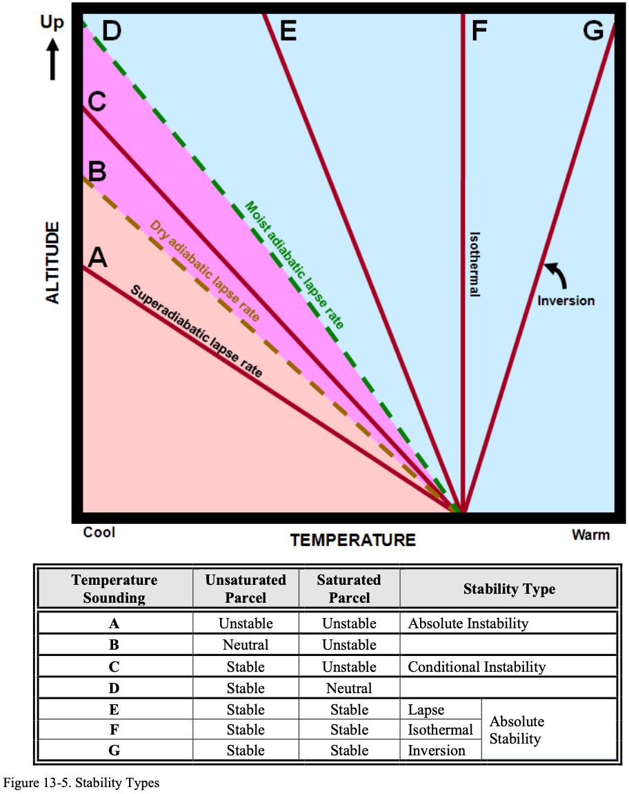
Atmospheric Stability
The tendency of a parcel of air perturbed from its equilibrium to return back to its initial equilibrium or not
- Atmospheric stability is basically all about how the temperature of a parcel of air changes relative to the environment.
- Compare the actual, ambient lapse rate with the standard lapse rate
- In order to figure out if the air parcel is unstable or not we must know the temperature of both the rising air and the environment at different altitudes.
- The faster the environmental temperature decreases with height, relative to the air parcel, the less stable the atmosphere.
- This is because a (let's say) rising parcel of air will not cool as quickly as the environment, and thus will continue to rise.
- Similarly, because moisture reduces the lapse rate of a parcel of air, moisture leads to instability.
- The faster the environmental temperature decreases with height, relative to the air parcel, the less stable the atmosphere.
- See: https://www.spc.noaa.gov/exper/mesoanalysis/help/help_lllr.html
Temperature Inversion
A layer where temperature increases with altitude
- Temperature inversions can be a surface-based inversion or inversion aloft
- Most frequently caused by terrestrial radiation on a clear relatively still night
- If it were cloudy the clouds would trap the rising heat, and wind would mix up the air and prevent the inversion from forming
- If there is a surface-based inversion and high relative humidity can expect
- Fog, haze, or low clouds
- Smooth air
- Poor visibility
- Most frequently caused by terrestrial radiation on a clear relatively still night
NOTE
Temperature inversions create stability because an air parcel, as it rises and cools, will remain relatively cooler than the air temperature through the inversion. So the rising parcel will become cooler than the ambient air, and tend to settle back down.
- Differences in air density caused by changes in temperature result in a change in pressure.
- Lifted index is the difference found by subtracting the temperature of a parcel of air theoretically lifted from the surface to 500 millibars and the existing temperature at 500 millibars.
- The lifted index is computed as if a parcel of air near the surface were lifted to 500 millibars.
- As the air is 'lifted,' it cools by expansion.
- The temperature the parcel would have at 500 millibars is then subtracted from the existing 500 millibar (mb) temperature.
- The difference is the lifted index; it may be positive, zero, or negative.
- K-Index is an indication of the probability of thunderstorms
Stability of Air Masses
- Unstable Air Mass
- Happens when a cold air mass moves over a warm surface and is warmed from below
- Characterized by
- Good visibility
- Turbulence
- Cumuliform clouds
- Showery precipitation
- Unstable lapse rate
- Stable Air Mass
- Happens when a warm air mass is being cooled from below
- Characterized by
- Stratiform clouds
- Little vertical development - the air is stable so it will not tend to continue rising if perturbed, for example if forced up a mountain slope
- Steady, continuous precipitation
- Poor or restricted visibility
- Smooth air (very little turbulence)
- Stratiform clouds
Movement of Air Masses
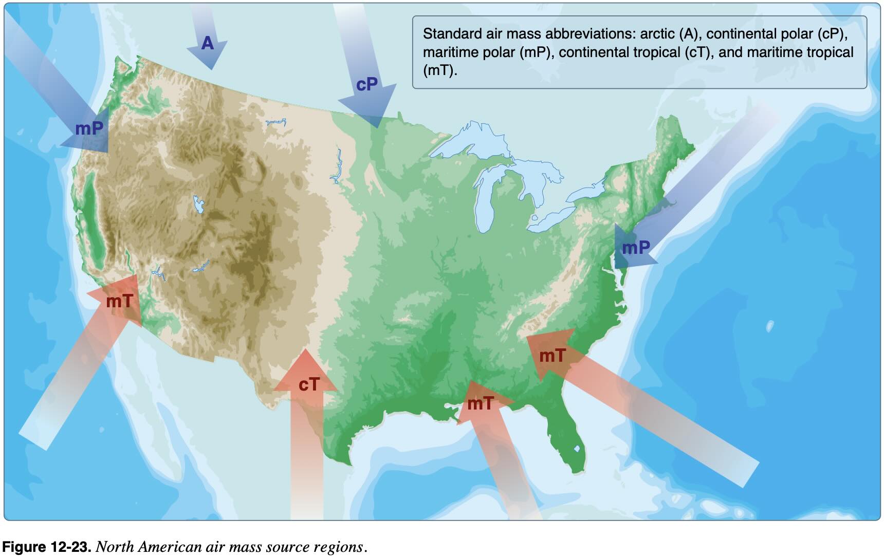
- Air masses are large bodies of air that take on the characteristics of the surrounding area or source region
- Polar / Tropical
- Maritime / Continental
- Air masses are generally identified as polar or tropical based on temperature characteristics and maritime or continental based on moisture content.
- Because moist air is less dense than dry air it tends to rise
- Moist air cools at a slower rate than dry air
- Thus it is generally less stable than dry air since the moist air must rise higher before its temperature cools to that of the surrounding air
- So cool dry air generally leads to good weather
- Warm moist air generally leads to bad weather
When air rises into an area of lower pressure, it expands to a larger volume. As the molecules of air expand, the temperature of the air lowers. As a result, when a parcel of air rises, pressure decreases, volume increases, and temperature decreases. When air descends, the opposite is true.
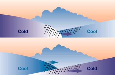
Fronts
- Front is the boundary layer between two types of air masses.
- An approaching front of any type always means changes to the weather are imminent.
- Knowing fronts is important for planning
- Example: ceiling will typically drop flying into a warm front, so be wary about planning VFR into a warm front.
- Types of Fronts
- Warm
- Cold
- Stationary
- Occluded
- Frontal waves normally form on slow-moving cold fronts or stationary fronts
- See FAA-AC-00-6B Aviation Weather for more on frontal waves

Warm Front
- Move slowly, 10-25 mph
- Light rain over a longer period of time
- This is due in part to their slow speed and also the shallowness of the frontal zone
- Prior to the passage of a warm front
- Cirriform or stratiform clouds, along with fog, can be expected to form along the frontal boundary.
- In the summer months, cumulonimbus clouds (thunderstorms) are likely to develop.
- Light to moderate precipitation is probable, usually in the form of rain, sleet, snow, or drizzle, accentuated by poor visibility.
- As the warm front approaches, the barometric pressure continues to fall until the front passes completely.
- During the passage of a warm front:
- Stratiform clouds are visible and drizzle may be falling.
- The visibility is generally poor, but improves with variable winds.
Cold Front
- Characteristics of a cold air mass moving over a warm surface:
- Cumuliform clouds
- Turbulence
- Good visibility
- Cool air moving over a warm surface is heated from below, generating instability and increasing the possibility of showers. Unstable air is characterized by cumuliform clouds, turbulence and good visibility.
- Move quickly, 25-30 mph and up to 60 mph
- heavy rain over a short period of time
- This is due in part to their fast speed and also the steepness of the frontal zone
- The rapidly ascending air causes the temperature to decrease suddenly, forcing the creation of clouds.
- Prior to the passage of a typical cold front
- Cirriform or towering cumulus clouds are present, and cumulonimbus clouds may develop
- Rain showers may also develop due to the rapid development of clouds.
- A high dew point and falling barometric pressure are indicative of imminent cold front passage.
- As the cold front passes
- Towering cumulus or cumulonimbus clouds continue to dominate the sky.
- Depending on the intensity of the cold front, heavy rain showers form and may be accompanied by lightning, thunder, and/or hail.
- More severe cold fronts can also produce tornadoes.
- During cold front passage, the visibility is poor with winds variable and gusty
Comparison Between Cold and Warm Fronts
- Cold fronts
- Move faster
- Bring worse weather
- Weather doesn't occur in advance of frontal boundary
Stationary Front
Stationary Front
When two fronts come together, and when the forces of two air masses are relatively equal, the boundary or front that separates them remains stationary and influences the local weather for days.
- Front is moving less than 5 knots
- The weather associated with a stationary front is typically a mixture that can be found in both warm and cold fronts.
Occluded Front
Occluded Front
Occurs when a fast-moving cold front catches up with a slow-moving warm front.
- As the occluded front approaches, warm front weather prevails but is immediately followed by cold front weather.
- A wide variety of weather can be found along an occluded front, with thunderstorms possible, but usually their passage is associated with a drying of the air mass.
- Warm air is lifted (occluded) from the ground
- A front is considered to be an occluded front once the warm air at the surface is cut off from the surface low pressure system.
- Cold front occlusion
- Cold front is colder than the air ahead of the slow moving warm front
- Creates a mixture of weather found in both warm and cold fronts, providing the air is relatively stable
- Warm front occlusion
- Cold front is warmer than the air ahead of the slow moving warm front
- The cold front rides up and over the warm front. If the air forced aloft by the warm front occlusion is unstable, the weather is more severe than the weather found in a cold front occlusion. Embedded thunderstorms, rain, and fog are likely to occur.
Moisture / Precipitation
Clouds
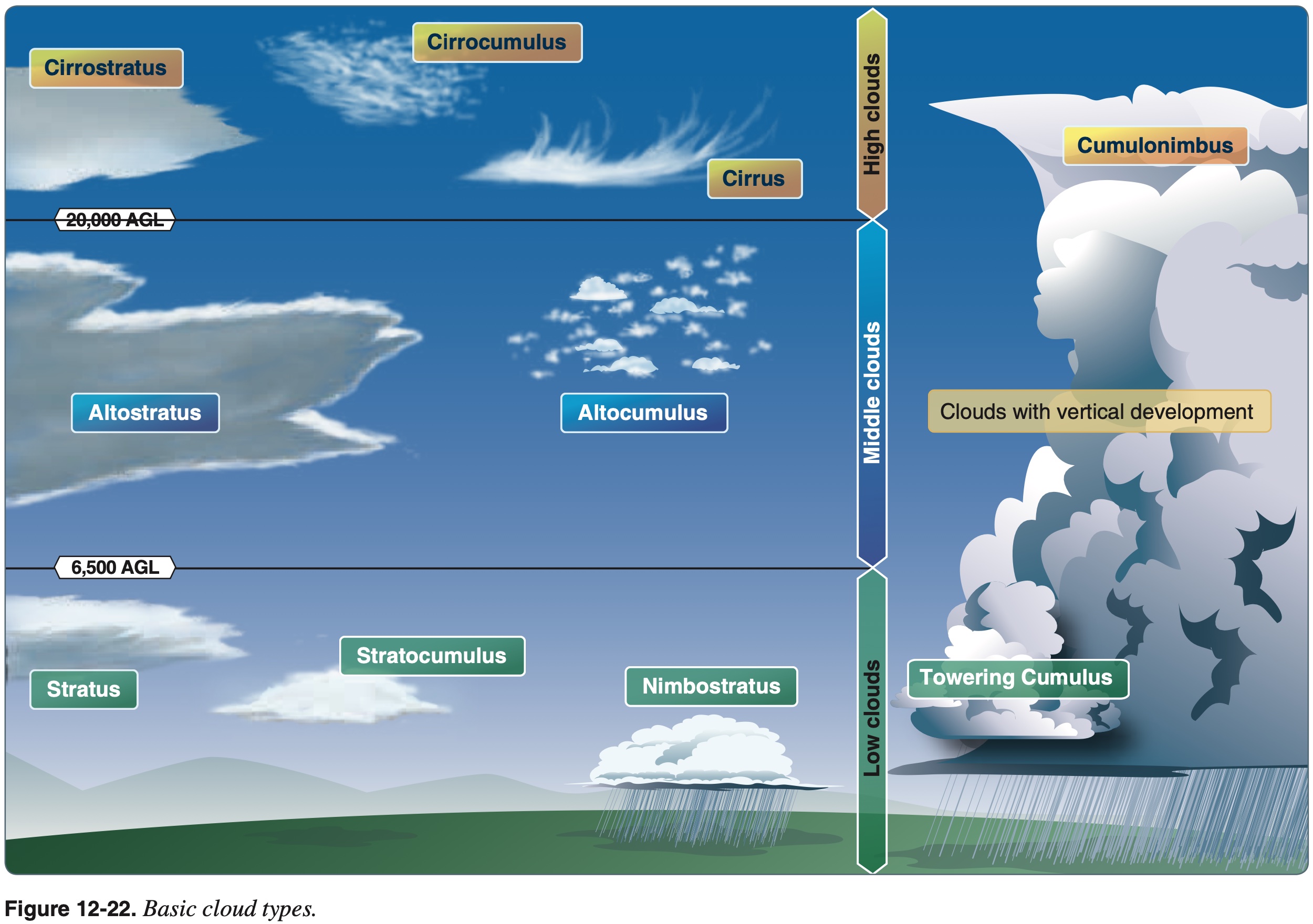
- Cloud type is determined by its height, shape, and characteristics. They are classified into the following four classes according to the height of their bases as well as one class based on significant vertical development:
- Low clouds
- Middle clouds
- Bases from 6,500 to 23,000 ft.
- High clouds
- Clouds with vertical development
- Nimbo - Rain
- Stratus - Layers
- Cumulo - Heap or pile (Latin)
- Nimbostratus
- Type of middle cloud
- Poses serious icing problem due to all the moisture
- Cumulonimbus Mammatus
- Violent turbulence
- Tend to produce funnel clouds (tornados that have not yet touched the ground)
Fog
- High relative humidity needed for fog to form
- All fog is a result of the temperature of air decreasing until it becomes completely saturated
- Fog is formed by moist air cooling to below its dew point
- Can expect or anticipate fog when the temperature/dew point spread is 5 °F (2 °C) or less and decreasing
- Fog typically occurs when the temperature of air near the ground is cooled to the air's dew point.
Fog Types
- Radiation fog
- Over land only
- Little to no wind present
- Ground cools (radiating its heat off into space) thus cooling the air above
- Forms most readily in warm moist air of low flatland inland areas on clear calm nights
- Advection fog
- Formed when warm moist air moves over colder ground or water
- Wind is required
- Fog deepens with wind up to 15 knots
- Beyond this the fog lifts into layer of low stratus clouds
- For example: air moving inland from the coast in winter
- Advection fog is more persistant than radiation fog
- Upslope fog
- Moist stable air moving up sloping terrain
- Wind is required
- Precipitation-induced fog
- Warm rain falls through cool air
- Cool air saturates and fog is formed
- Typically associated with a warm front
- Steam fog
- Cold dry air passes from land over warm ocean waters
- Water evaporates just like steam
- Do not fly through steam fog - is a particular icing hazard to aircraft
- Ice fog
- Occurs in cold weather when the temperature is much below freezing and water vapor forms directly into ice crystals
- Conditions are same as radiation fog except for cold temperature, usually –25 def. F or colder
- Lake-effect fog
- Leeward (downwind) side of lake
- Seems same as steam fog?
Wind
Wind Shear
Wind Shear
Wind shear is a sudden, drastic change in wind speed and/or direction over a short distance.
- Wind shear can affect any flight and any pilot at any altitude.
- Low-level wind shear can be expected:
- During strong temperature inversions.
- On all sides and below thunderstorm.
- Near frontal activity.
- For warm fronts:
- Most critical period is before the front passes
- May exist up to 5,000 feet for about 6 hours after front passes
- Windshear associated with warm front usually more extreme than that found in cold fronts
- For cold fronts:
- Low-level wind shear usually associated with cold fronts?
- Shear behind the front
- If the front moving at 30 kts or more, shear zone will be 5,000 ft above the surface 3 hours after frontal passage.
- For warm fronts:
- Wind shear can also be found above a low-level temperature inversion with strong winds above the inversion.
Turbulence
- Greatest danger is on leeward (downwind) side of mountains when flying into the wind.
- Clear Air Turbulence (CAT)
- Typically encountered at 15,000 ft AGL or higher.
- Not associated with thunderstorms or cumulous type clouds.
- Avoid horizontal changes more than 40 knots within 150 miles to avoid CAT.
- See winds aloft chart.
- See also Jetstream.
Mountain Wave
- Conditions for formation of mountain wave
- Mountainous area
- Stable air at mountain altitude
- Wind at least 20 mph blowing across mountain ridge
- Lenticular clouds form at crest of each wave
- Usually not turbulent in lenticular clouds but rather below at ridgetop level in the rotor clouds and below the rotor clouds
Thunderstorms
There are three ingredients that must be present for a thunderstorm to occur:
- Moisture
- Unstable lapse rate
- Lifting action
Thunderstorm Types
- Single-cell
- Multi-cell cluster
- Multi-cell line (squall line)
- Supercell
From FAA-H-8083-25B Pilot's Handbook of Aeronautical Knowledge Chapter 12: Weather Theory:
Some storms occur at random in unstable air, last for only an hour or two, and produce only moderate wind gusts and rainfall. These are known as air mass thunderstorms and are generally a result of surface heating.
Steady-state thunderstorms are associated with weather systems.
Outside the cloud, shear turbulence has been encountered several thousand feet above and 20 miles laterally from a severe storm.
Gust fronts often move far ahead (up to 15 miles) of associated precipitation.
- Wind shear turbulence within 20 nm of thunderstorm
- Avoid severe thunderstorms by at least 20 nm as they can throw out hail
- Hail is
- Usually found in thunderstorms with strong updrafts and a high water content
- Produced during the mature stage
- Found beneath the anvil cloud
Squall line
Squall Line
A narrow band of active thunderstorms.
- Often associated with a fast-moving cold front
- Very likely to spawn tornados
From FAA-H-8083-25B Pilot's Handbook of Aeronautical Knowledge Chapter 12: Weather Theory:
Often it develops on or ahead of a cold front in moist, unstable air, but it may develop in unstable air far removed from any front.
- Non-frontal
- Often develop ahead of a cold front
Thunderstorm Stages
- Cumulus stage
- Continuous updrafts
- Mature stage
- Updrafts and downdrafts inside the cloud
- Start of rain at surface is beginning of mature stage
- Dissipating stage
- Mainly downdrafts

Microbusts
- Can have maximum downdrafts of 6000 ft/min.
- Last usually not more than 15 minutes.
- Maximum winds usually last 2-4 minutes.
- Create vertical and horizontal windshear.
Icing
- Aircraft structural icing
- For ice to form need
- Visible moisture
- Temps freezing or below
- Typically forms on wing and propellor
- Clear ice
- Most rapid ice formation
- Typically forms in cumuliform clouds
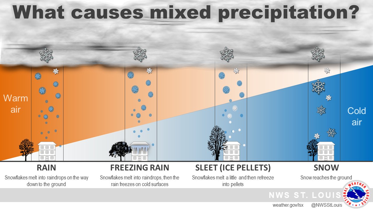
- Freezing rain
- Rain falling from warmer air into air that is colder than freezing
- Ice pellets indicates there is freezing rain above
- For ice to form need
Icing Regulations
Known icing conditions
- Note: Part 91 was updated since this letter to include 14 CFR §91.527
"Known icing conditions" involve instead circumstances where a reasonable pilot would expect a substantial likelihood of ice formation on the aircraft based upon all information available to that pilot.
Whether a pilot has operated into known icing conditions contrary to any limitation will depend upon the total information available to the pilot, and his or her proper analysis of that information in evaluating the risk of encountering known icing conditions during a particular operation.
Atmospheric conditions in which the formation of ice is observed or detected in flight. Note-Because of the variability in space and time of atmospheric conditions, the existence of a report of observed icing does not assure the presence or intensity of icing conditions at a later time, nor can a report of no icing assure the absence of icing conditions at a later time.
Discussion
Know what the weather is doing to avoid bad weather, take advantage of favorable winds, and when local air currents may disturb flight. When presented with these different weather phenomena in various weather products, be able to understand and put together a comprehensive picture of the weather, and ultimately be able to make a go-no-go decision.
References
- FAA-H-8083-28A Aviation Weather Handbook
- AIM 7-1-28 Key to Aerodrome Forecast (TAF) and Aviation Routine Weather Report (METAR)
- FAA-H-8083-25B Pilot's Handbook of Aeronautical Knowledge
- Chapter 4: Principles of Flight
- Chapter 12: Weather Theory
- Chapter 13: Aviation Weather Services
- Page 13-4: Transcribed Weather Broadcast (TWEB) (Alaska Only)
- FNL Pilots METAR Remarks
- FAA METAR Abbreviations
- http://meteocentre.com/doc/metar.html
- Note FAA-H-8083-28A ultimately will cancel the following