CFII Study Guide
Preflight Preparation
I.A. Pilot Qualifications
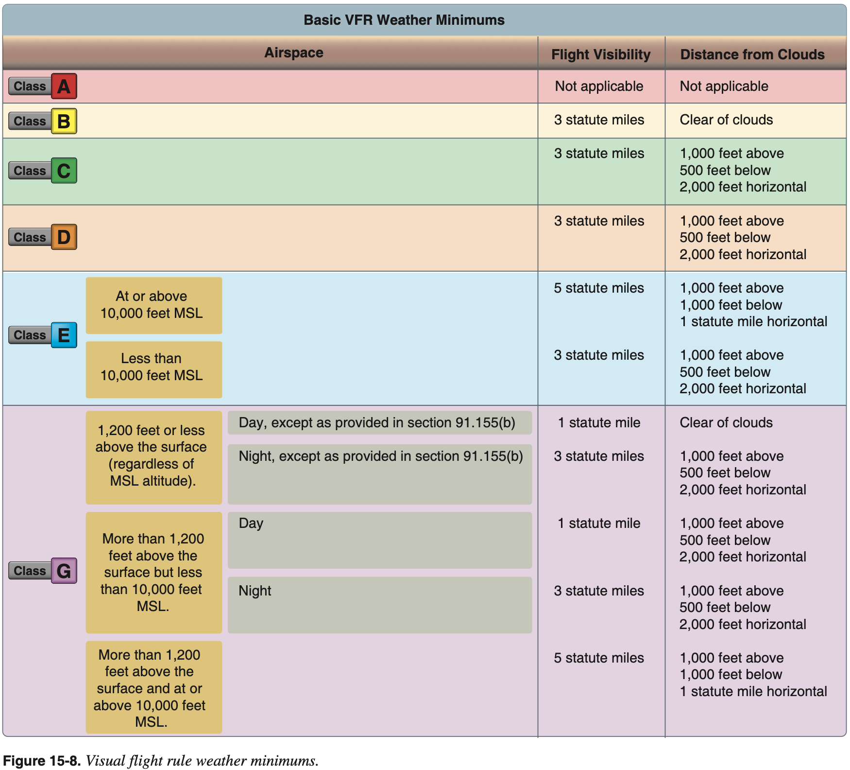
Scenario: You are taking 2 friends, Joe and Colin up to the Allegheny County Airport today to visit other friends. Many of the questions involve your preparation for that flight. The weather at your departure airport at your your time of departure is winds 340@14, 800' overcast, temp +5 °C. Weather at AGC is winds 300@12, 400' overcast, temp +8 °C
- Could you legally fly this flight as a private pilot without an instrument rating?
- No, we can not climb into the clouds on departure, or descend through them to land at AGC
- See chart below for VFR weather minimums
- We'd plan this flight using the Arsenal 5 departure Linden transition
ARSNL5.LDNthen direct- This was overwhelmingly the most used IFR route for this departure/destination pair on the ForeFlight route planner
- What other privileges do you have as an instrument pilot vs. a private pilot alone?
- Flight under IFR or in weather less than VFR
- 14 CFR §61.3(e) Instrument rating
- "No person may act as pilot in command of a civil aircraft under IFR or in weather conditions less than the minimums prescribed for VFR flight unless that person holds ... instrument rating on that person's pilot certificate."
- 14 CFR §61.3(e) Instrument rating
- Flight in Class A airspace
- 14 CFR §91.135 Operations in Class A airspace
- "Each person operating an aircraft in Class A airspace must conduct that operation under instrument flight rules (IFR)."
- 14 CFR §91.135 Operations in Class A airspace
- Special VFR at night
- Technically it is between sunset and sunrise
- 14 CFR §91.157(b)(4)
- "The person being granted the ATC clearance meets the applicable requirements for instrument flight under part 61 of this chapter."
- Also as a commercial pilot without an instrument rating, carrying passengers for hire on cross countries longer than 50 nm or at night is prohibited.
- 14 CFR §61.133 Commercial pilot privileges and limitations
- "The carriage of passengers for hire in airplanes on cross-country flights in excess of 50 nautical miles or at night is prohibited."
- 14 CFR §61.133 Commercial pilot privileges and limitations
- Flight under IFR or in weather less than VFR
- Additional currency requirements by adding an instrument rating?
- Use 66 HIT to remember instrument currency requirements
- 6 Approaches within
- 6 months including
- Holding
- Procedures and tasks
- Intercepting
- Tracking
- Courses through the use of navigational electronic systems
- 14 CFR §61.57(c) Instrument experience
- Per aircraft category
- e.g. airplane, helicopter
- After instrument currency lapses there is a 6 month "grace period" during which you are not instrument current, but can still complete the above to become curent.
- After that need to complete an IPC
- 14 CFR §61.57(d) Instrument proficiency check
- Use 66 HIT to remember instrument currency requirements
- Logging requirements?
- Log the requirements of 66 HIT
- Approaches
- Location
- Type
- Holds
- Name of the safety pilot if used
- Approaches
- 14 CFR §61.51 Pilot logbooks
- "Each person must document and record ... the aeronautical experience required for meeting the recent flight experience requirements of this part."
- 14 CFR §61.51(g) Logging instrument time
- "A person may log instrument time only for that flight time when the person operates the aircraft solely by reference to instruments under actual or simulated instrument flight conditions."
- "For the purposes of logging instrument time to meet the recent instrument experience requirements of §61.57(c) of this part, the following information must be recorded in the person's logbook - (i) The location and type of each instrument approach accomplished; and (ii) The name of the safety pilot, if required."
- Log the requirements of 66 HIT
- What endorsements can you give as a CFII that you cannot as a CFI?
- Instrument knowledge test
- Including review of deficiencies
- Retest endoresment
- Instrument Proficiency Check (IPC)
- Endorse for practical test
- Instrument knowledge test
- Safety pilot logging?
- See above
- Log the name of safety pilot
- Be in agreement ahead of time who is acting PIC
- If the safety pilot is acting as the PIC and the pilot under the foggles is the sole manipulator of the flight controls, both can log PIC
- Special emphasis areas
- Runway Incursion
- Hot Spots
- See Airport Hot Spots
- Be sure to be familiar with airport hot spots and brief their location and precautionary action to be taken before taxiing.
- LAHSO
- See LAHSO
- When a runway intersects another runway, taxiway, or flight path
- Don't need to accept, but should if you can
- Make sure if you do accept that you can meet the requirements
- More info in Digital Terminal Procedures Publication (d-TPP)/Airport Diagrams
- Signs
I.B Weather Information
- What weather, airport, and aircraft factors effect our performance?
- Weather
- Air temperature and density
- More air is better for combustion and aerodynamics
- Winds
- Headwind or tailwind
- Moisture / dewpoint
- Potential for icing
- Air temperature and density
- Airport
- Runway
- Length
- Surface conditions
- Surrounding terrain
- What performance do we need to achieve to avoid terrain
- Airport elevation
- Directly affects air density
- Available approaches
- Impact our ability to get into an airport
- Consider approaches off both ends of runway in case after takeoff there is an urgent need to return for landing
- Lighting
- May impact our ability to see and get down and land at correct airspeed
- Runway
- Aircraft
- Weight
- Use POH to determine takeoff performance
- How we fly the aircraft impacts performance
- Are we pitching for
or as required
- Are we pitching for
- Configuration
- Are we using the correct configuration
- Equipment
- What approaches can the plane fly to get back in
- Do we have anti/de-ice to prevent performance impacts of icing
- Engines
- Performance in the event of an engine failure
- Weather
- METAR, TAF
- Meteorological Terminal Aviation Routine Weather Report (METAR)
- Provide local weather conditions and other relevant information for a specific airport
- Terminal Aerodrome Forecast (TAF)
- Covers five statute mile radius around an airport
- Valid for a 24 or 30-hour time period
- Updated four times a day at 0000Z, 0600Z, 1200Z, and 1800Z
- 30 hour TAFs are usually at airports that serve long-range aircraft, so they can get their TAFs more in advance before taking off
- Some common terms and descriptors
NSW- No significant weather
SKC- Sky clear
TEMPO- Last for less than an hour and occur during less than half of the time period specified
AUTO- When METAR countains
AUTOit means there was no human intervention to augment the report with information like thunderstorms in vicinity
- When METAR countains
$- At the end of METAR
$indicates system that generated it may be in need of maintenance
- At the end of METAR
AO1- Thinks any precipitation is rain
AO2- Can tell the difference between types of precipitation
PRESRR- Pressure rising rapidly
- When pressure is rising or falling rapidly it means winds will be strong
LTGIC- Lightning in cloud
LTGCC- Lightning cloud to cloud
LTGCG- Lightning cloud to ground
- Meteorological Terminal Aviation Routine Weather Report (METAR)
Example 1
KIAD 241952Z 31005KT 1/2SM R01R/2000V2800FT FG VV002 07/06 A2946 RMK
AO2 RAE19 SLP978 P0001 T00670061- METAR
241952Z- Issuance time
31005KT- Winds 310 at 5 knots
1/2SM- Half statute mile visibility
R01R/2000V2800FT- RVR Runway 01R is variable between 2000 and 2800 feet
FG- Fog
VV002- Vertical visibility 200 feet
07/06- Temperature 7 °C, dewpoint 6 °C
A2946- Altimeter setting in inches of mercury
- Remarks
AO2- Automated station without manual augmentation
- Can tell the difference between types of precipitation
RAE19- Rain ended 19 minutes past the hour
SLP978- Sea Level Pressure in mbar
- To get Sea Level Pressure need to prepend a
9or10, to get a value that is closest to 1000 mbar - In this case we prepend
9to get9978or 997.8 mbar - If we prepended a
10the value would be too large
P0001- Hourly precipitation in hundredths of an inch (0.01 inches) since last METAR
T00670061- Hourly temperature 6.7 °C and dewpoint 6.1 °C
- The leading
0of each four digit group indicates the values are positive, a leading1indicates the values are negative
Example 2
KDCA 242036Z 14016KT 4SM RA BR BKN019 BKN047 OVC070 17/15 A2943 RMK
AO2 PRESFR P0004 T01670150- METAR
PRESFR- Pressure falling rapidly
- When pressure is rising or falling rapidly it means winds will be strong
Example 3
KRBD 112153Z 18013G25KT 10SM CLR 12/M03 A2982 RMK AO2 PK WND 19026/2122
SLP099 T01171028
Example 4
SPECI KDAL 041140Z COR 30034G68KT 3/4SM R13L/2800VP6000FT +TSRA BR SQ
FEW011 BKN017 OVC023CB 11/10 A2953 RMK A02 PK WND 29068/1134 WSHFT 1121
TSB10 FRQ LTGICCC ALQDS TS ALQDS MOV NE P0012 T01060100SPECI- Special issuance METAR
KDAL- Dallas Love Field
041140Z- Issuance time
COR- Corrected observation (as opposed to automated)
30034G68KT- Winds
3/4SM- Visibility
R13L/2800VP6000FT- RVR
+TSRA BR SQ- Heavy thunderstorms, rain, squalls
FEW011 BKN017 OVC023CB- Clouds
11/10- Temp and dewpoint in Celcius
A2953- Altimeter setting in inHg
- Remarks
A02- Automated station without manual augmentation
- Can tell the difference between types of precipitation
PK WND 29068/1134- Peak wind 290 at 68 knots that occured at 1134Z
WSHFT 1121- Wind shifted at 1121Z
TSB10- Thunderstorms began 10 minutes past the hour (1110Z)
FRQ LTGICCC ALQDS- Frequent lightning in clouds, cloud-to-cloud, in all quadrants
TS ALQDS MOV NE- Thunderstorms in all quadrants moving northeast
P0012- Hourly precipitation in hundredths of an inch (0.01 inches) since last METAR
T01060100- Hourly temperature 10.6 °C and dewpoint 10.0 °C
- The leading
0of each four digit group indicates the values are positive, a leading1indicates the values are negative
Example 1
KIAD 241741Z 2418/2524 10006KT 2SM -RA OVC006 WS020/17040KT
    FM242000 14015G23KT 3SM -SHRA VCTS OVC015CB
    TEMPO 2420/2424 VRB40KT 1SM +TSRA BKN008 OVC015CB
    FM250000 18012G16KT 6SM -SHRA BKN040
    FM250200 20014G21KT P6SM BKN060
    FM251300 26018G27KT P6SM BKN050
TAF
241741Z- Issuance time
2418/2524- Valid period
WS020/17040KT- Wind shear 2000 AGL
- Wind 170 at 40 knots at the top of the wind shear layer
VCTS- Thunderstorms in the vicinity
Winds aloft, AIRMETs, SIGMETs, convective sigmets, CB avoidance
- Winds Aloft
- Winds and temps aloft are forecasts based on observations made a few hours prior
- Made twice a day based on the radiosonde upper air observations taken at 0000Z and 1200Z
- Format
DDSSTTwhereDis wind directionSis wind speedTis temperature
- Example
2321-04is wind from 230 at 21 knots and temperature -21 °C - No temp is given for 3,000 ft MSL or when 2,500 ft AGL
- Above 24,000 feet all temperatures are negative so minus sign is dropped
- Wind
9900means light and variable (less than 5 kts) - For winds greater than 99 knots, subtract
50from theDDgroup and add 100 to theSSgroup to get actual wind speed and direction- Example:
7545means winds of 145 knots from 250
- Example:
- See also the graphical version Winds and Temperatures Aloft (FB)
- See Aviation Weather Center's Winds/Temps Data
- AIRMET (WA)
- Stands for Airmen's Meteorological Information
- Of operational interest to all aircraft
- Potentially hazardous to light aircraft
- Pilots of heavy aircraft aren't really going to worry about AIRMETs
- Forecasts valid for 6 hours
- Issued every 6 hours, as well as unscheduled updates
- 3 Types
- Sierra: describes IFR conditions and/or extensive mountain obscurations, widespread areas of ceilings less than 1,000 feet and/or visibilities less than three miles
- Tango: moderate turbulence, sustained surface winds 30kts or greater, low level wind shear
- Zulu: moderate icing and freezing level heights
- Less intense than requiring a SIGMET, used in preflight to enhance flight safety
- https://www.aviationweather.gov/sigmet/help
- The definition here is a bit different than in PHAK, for example
- SIGMET (WS)
- Stands for Significant Meteorological Information
- Potentially hazardous to all categories of aircraft
- Forecasts valid for 4 hours
- Types
- Severe icing not associated with thunderstorms
- Severe turbulence / clear air turbulence (CAT) not associated with thunderstorms
- IMC due to sandstorms, volcanic ash
- Significant Meteorological Information AIM 7-1-6 Inflight Aviation Weather Advisories
- Convective SIGMET (WST)
- Advises of significant weather due to thunderstorms
- Severe or greater turbulence, severe icing, low-level wind shear
- Hazardous to all categories of aircraft
- Issued hourly at H+55
- Forecasts valid for 2 hours
- Conditions to issue Convective SIGMET
- Severe thunderstorms due to 50 kts or greater surface winds or hail more than 3/4" in diameter
- Tornadoes
- A line of thunderstorms 60+ nm long
- Severe or embedded thunderstorms for 30+ minutes
- Area of thunderstorms covering at least 40% of the area concerned and exhibiting a very strong radar reflectivity or a significant satellite or lightning signature.
- CB Avoidance
- Use all weather products available to determine likelihood of convective activity along route of flight
- Use onboard and other resources available during flight to get updated information during flight
- Avoid thunderstorms by at least 20 nm
- Exercise good ADM to avoid convective activity
- Winds Aloft
I.C. Cross Country Flight Planning
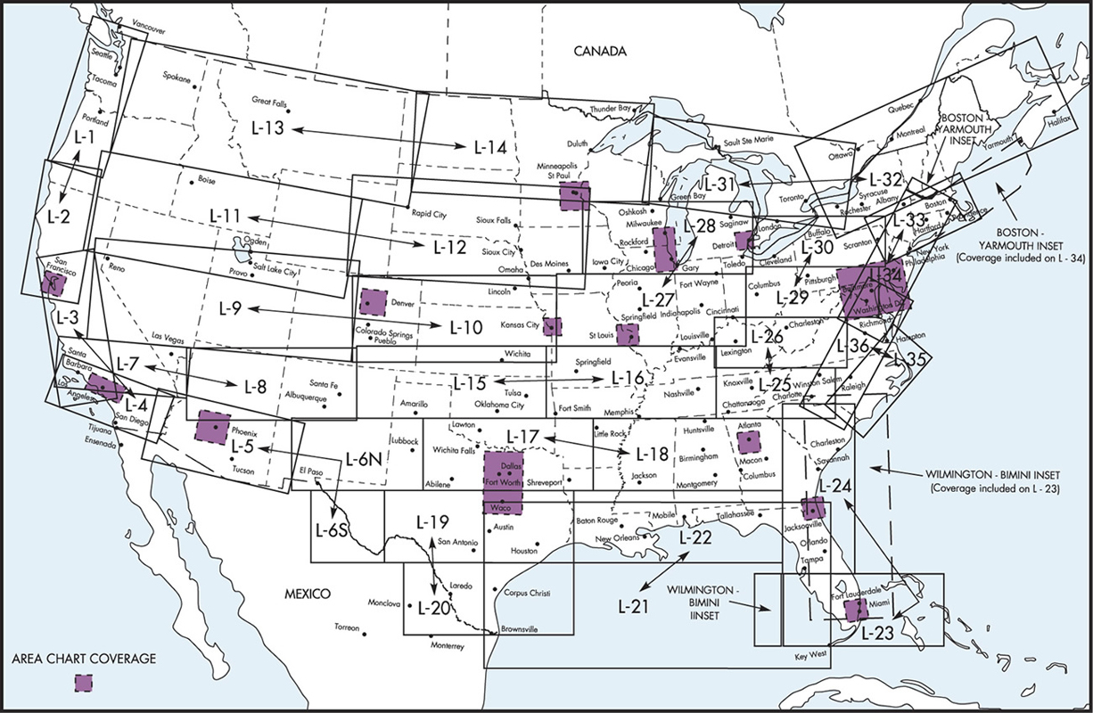
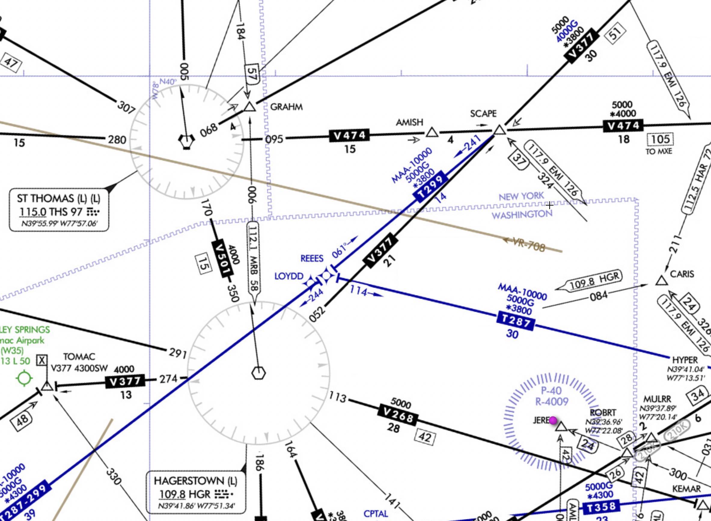
- Cross country flight planning to AGC. Chart symbols
- See FAA Aeronautical Chart Users' Guide
- Seems to now be a single guide for all charts
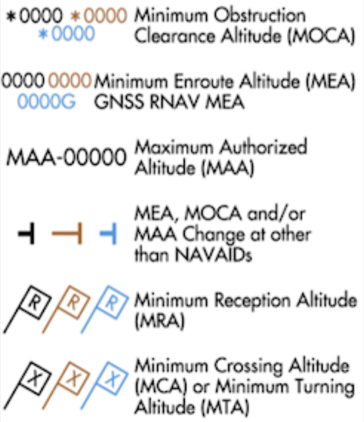
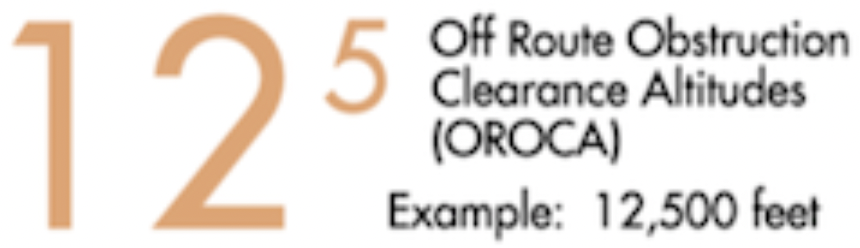
- IFR low chart symbols
- IFR Enroute Aeronautical Charts and Planning
- Green or Blue have an IAP or radar minima
- Blue airports have high approaches, ones that start at around 18,000' MSL
- Brown airports do not have an IAP or radar minima
- Radar minima means there are published minima for ASR or PAR approach
- Compulsory reporting points are solid
- Navaids list Service Volumes (SSV) for VOR, DME, and TACAN separately
- For example for the Casanova VORTAC,
CSN (H) (H)means VOR(H)and TACAN(H)service volumes - AIM 1-1-8 NAVAID Service Volumes
- For example for the Casanova VORTAC,
- Some VOR/VORTAC/TACAN on IFR low charts do not have a compass rose
- This does not mean they are terminal VORs
- Rather they may not have victor airways associated with them, or the compass rose may have been omitted for clarity
- See
LFI,DOV,ADW, andDENas some examples
- Airways that look like victor airways but that start with different letters are typically oceanic airways
- Military Training Routes (MTR)
- Denoted by
IRorVR - 3 digits if above 1,500' AGL, 4 digits if below
- Denoted by
- See FAA Aeronautical Chart Users' Guide
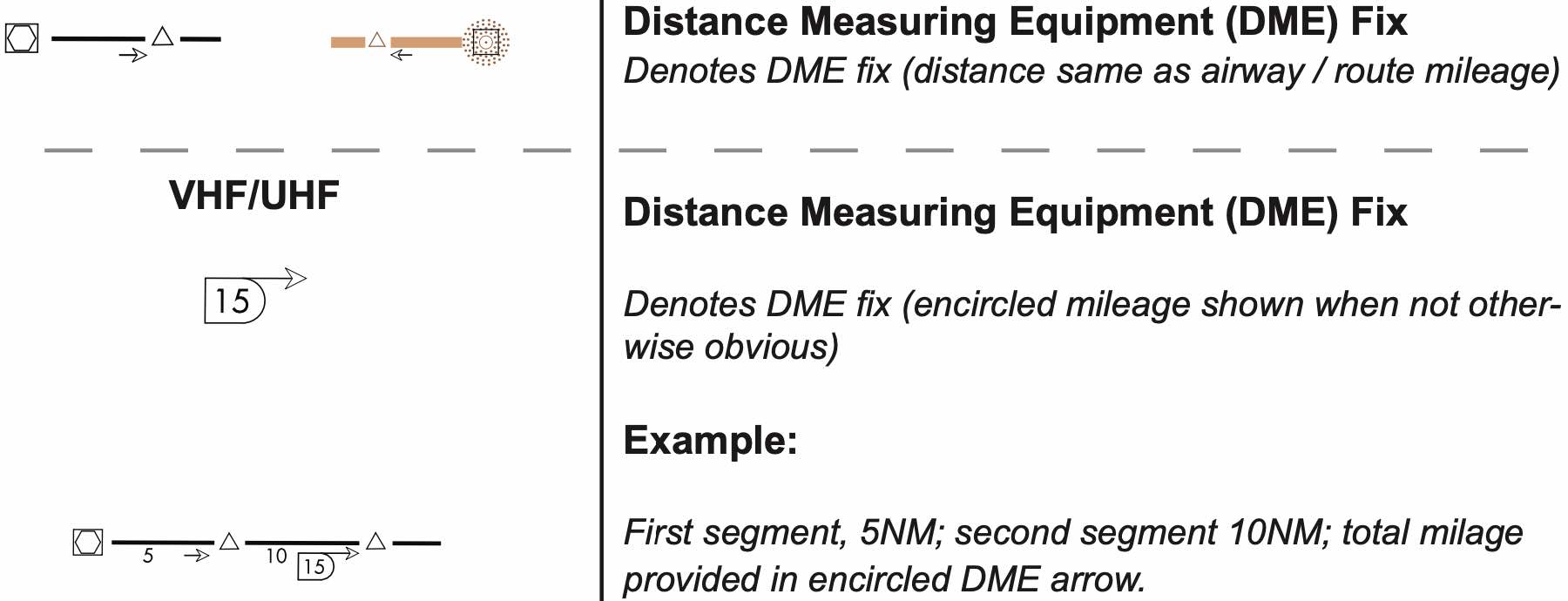
DME Distance Arrows on Low Enroute Chart
More Cross Country Flight Planning
- Alternates
- Do we need to file an alternate?
- If filing IFR to an airport without an instrument approach, you must have an alternate no matter what
- Otherwise apply the 1-2-3 rule
- If we do need an alternate, can I use a particular airport as my alternate?
- This depends on the weather at the ETA
- Check the TERPs for that airports alternate minimums
- Otherwise use "standard" alternate minimums of 600-2 and 800-2
- Also in TERPS check for "NA when local weather not available." - if the weather reporting equipment at the alternate is out as reported by NOTAM then the airport cannot be used as an alternate
- Do we need to file an alternate?
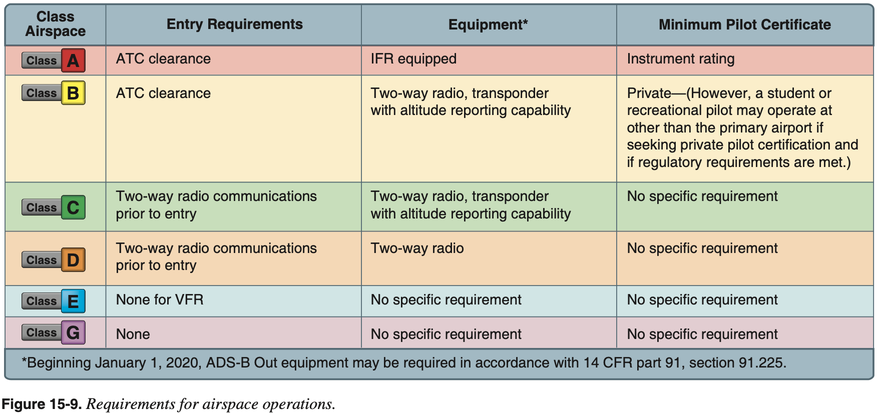
- Airpsace
- Mode-C and ADS-B required in
- Class A, B, and C airspace
- Class E airspace at or above 10,000' MSL (excluding airspace at and below 2,500' AGL)
- Mode-C veil (30 nm) up to 10,000' MSL
- Above Class C airspace up to 10,000' MSL
- Class E airspace over the Gulf of Mexico, at and above 3,000' MSL, within 12 nm of the U.S. coast
- 14 CFR §91.225 - Automatic Dependent Surveillance-Broadcast (ADS-B) Out equipment and use
- Mode-C and ADS-B required in
- What required ATC reports and calls are specific to instrument flights?
Mandatory Reporting Points
- Required reports (MARVELOUS VFR C500)
- M - Missed approach
- A - Airspeed
- +/- 10 kts or 5% of filed TAS (whichever greater)
- ATC basically wants to know if we are making a deliberate power change
- R - Reaching a holding fix
- Time and altitude
- Crossing the holding fix outbound as part of our entry procedure
- V - VFR on-top altitude changes
- E - ETA change
- Of more than +/- 2 minutes
- In non-radar environment
- L - Leaving a holding fix
- O - Outer marker inbound
- In non-radar environment
- Outer marker indicates final approach fix for non-precision approach
- U - Unforecast weather
- Especially icing, turbulence, wind
- S - Safety of flight
- V - Vacating an altitude or flight level
- F - FAF inbound
- In non-radar environment
- R - Radio or navigation failure
- Report loss of any equipment which may impair safety and/or ability to operate under IFR
- AIM 5-3-3 a.1 (h)
- 14 CFR §91.187
- C - Compulsory reporting points
- In non-radar environment
- 500 - Failure to maintain at least 500 FPM climb or descent
Position Reports
How to report one of the above (PTA PT P)
- P - Point
- T - Time
- A - Altitude
- P - Point
- T - Time
- P - Point
- For example
- "Potomac Approach, Skyventures 124 is over CSN at 4000 feet 30 minutes after the hour, expect BRV at 45 minutes after the hour, then FAK"
Position reports
- Position reports are required over each compulsory reporting point along the route being flown
- Shown on the chart as a solid triangle
- Along direct routes, reports are required of all IFR flights over each point used to define the route of flight
- Position reports should include the following items:
- Identification
- Position
- Time
- Altitude
- Type of flight plan
- Estimated time of arrival (ETA) and name of next reporting point
- The name only of the next succeeding reporting point along the route of flight
- Remarks
- Position reports are required over each compulsory reporting point along the route being flown
Loss of radar coverage reports
- For the scenario in this question, consider a flight to the Bahamas some time after a hurricane had passed through disabling secondary radar coverage, thus requiring pilots to make position reports on their flight.
- See FAA VFR Raster Charts Carribean - 1 chart
- See required reports (MARVELOUSVFRC500) and how to report (PTA PT P) above
- Recap of the ones specific to non-radar environment
- E - ETA change
- Of more than +/- 2 minutes
- O - Outer marker inbound
- F - FAF inbound
- C - Compulsory reporting points
- This includes points which define the route of flight
- E - ETA change
- Applying (PTA PT P) to a call we might make on the Bahamas chart
- "Miami Center, Skyventures 124 is over BIMINI at 4000 feet 15 minutes after the hour, expect CAREY at 45 minutes after the hour, then NASSAU"
- Note: in the above example, the use of time in reference to minutes before or after the hour avoids confusion across time zone. Otherwise, use Zulu time instead of local time to similarly avoid confusion.
- For the scenario in this question, consider a flight to the Bahamas some time after a hurricane had passed through disabling secondary radar coverage, thus requiring pilots to make position reports on their flight.
Emergency Operations
VII.A Loss of Communications Procedures
Communication Failure Under IFR
- If the radio fails while VFR, fly VFR and land as soon as practicable
- Squawk 7600
- Unless you decide to declare an emergency, then squawk 7700
- The following rules determine the route and altitude that should be be flown should a radio failure happen in flight and the flight is continued
- If flight needs to be continued IFR after losing communications, the following route should be flown (AVEF)
- A - Assigned
- In last ATC clearance
- V - Vectored
- E - Expected
- From last ATC communication
- F - Filed
- In flight plan
- A - Assigned
- If flight needs to be continued IFR after losing communications, the highest of the following altitude should be flown (MEA) for each route segment
- M - Minimum altitude for IFR operations
- E - Expected
- From last ATC communication
- A - Assigned
- In last ATC clearance
- See 14 CFR §91.185 IFR operations: Two-way radio communications failure
- If radio failure happens and clearance limit is the fix from which approach begins, start descent and approach as close as possible to EFC time, or to arrive at estimated arrival time from flight plan (or amended enroute.)
- If clearance limit is not a fix from which approach begins, leave the clearance limit at EFC time or arrival at the fix if no EFC time, and start approach to begin as close as possible to estimated time of arrival from flight plan (or amended enroute.)
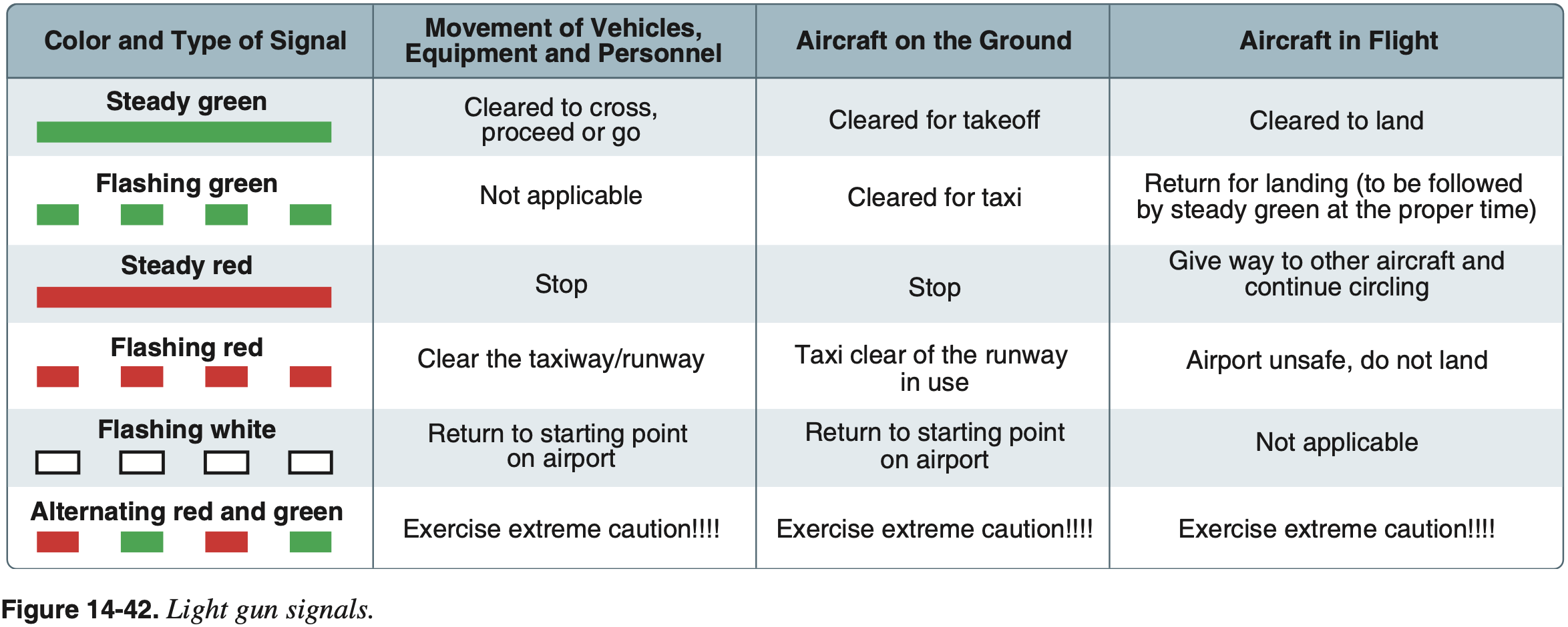
Light Gun Signals
Troubleshooting
- Check frequency
- Check volume
- Try previous frequency
- Try other radio
- Check for TX/RX
- Try other headphone jacks
- Try other PTT
- Try handheld mic
- Try overhead speaker
- Try EMG
- Try other headset
- Otherwise go 7600
References
- FAA-H-8083-15B Instrument Flying Handbook
- Chapter 11: Emergency Operations
- Page 11-8: Communication/Navigation System Malfunction
- Chapter 11: Emergency Operations
Preflight Procedures
II.A Airplane Systems Related to IFR Operations
- Is this plane certified for FIKI?
- Do we have any de-ice/ anti-ice systems? How do they work?
- De-ice vs. anti-ice
- Anti-ice is preventative
- It prevents ice from accumulating
- De-ice is reactive
- It removes ice after it has already formed
- Anti-ice is preventative
- Windscreen defrost
- Use waste heat from the engine and blow warm air on windscreen
- Pitot heat
- Electrically heated
- De-ice vs. anti-ice
II.B Airplane Flight Instruments and Navigation Equipment
- What aircraft checks and inspections are specific to instrument flying?
- Use the AVIATE acronym to remember required aircraft inspections.
- A - Airworthiness Directives (AD)
- Need to find all applicable ones and make sure they are complied with
- Where to find list of all applicable ADs to a given aircraft?
- Can look up FAA Airworthiness Directives (ADs)
- Q: But how to figure out which should apply to a particular aircraft?
- V - VOR (every 30 days for IFR)
- Note: only required by 14 CFR §91.205 if needed for route of flight to be flown
- For example, consider a flight using GPS to an airport with GPS approach, and either not requiring an alternate or in a WAAS-equipped plane where both the destination and alternate only need GPS approaches
- 14 CFR §91.171(a)(2)
- VOR accuracy requirements 14 CFR §91.171(b), (c)
- VOT: +/- 4 deg
- Ground checkpoint: +/- 4 deg
- Airborne checkpoint: +/- 6 deg
- Dual check: within 4 deg
- Logging
- Date
- Place
- Bearing error
- Signature
- Note: only required by 14 CFR §91.205 if needed for route of flight to be flown
- I - Inspections
- Annual (and 100 hour if for hire) 14 CFR §91.409(a)(1) and 14 CFR §91.409(b)
- A - Altimeter/static system (every 24 calendar months for IFR)
- T - Transponder (every 24 calendar months)
- E - ELT (every 12 months)
- 14 CFR §91.207(d)
- Also need to replace/recharge battery at 50% life or after 1 hour of cumulative use
- VOR checks: frequency, methods, tolerances, logging
- See above
- How often must pitot-static check be performed?
- Within previous 24 calendar months
- How do you determine your own personal fitness to fly?
- Use the IMSAFE checklist
- I - Illness
- M - Medication
- S - Stress
- A - Alcohol
- F - Fatigue
- E - Eating / Emotion
- Use the IMSAFE checklist
- What are the risks of flying well not feeling well?
- Safety of flight can be impacted
- Physiological or mental discomfort or illness can be a distraction or affect senses so the pilot is not able to safely perform required duties
- Cognition can be affected
VOR Check
- Recall from AVIATE acronym, VOR needs to be checked every 30 days for IFR
- VOR accuracy requirements 14 CFR §91.171(b), (c)
- VOT: +/- 4 deg
- Can be checked on the ground or in the air, as indicated in the chart supplement for that facility
- Ground checkpoint: +/- 4 deg
- Airborne checkpoint: +/- 6 deg
- Dual check: within 4 deg
- VOT: +/- 4 deg
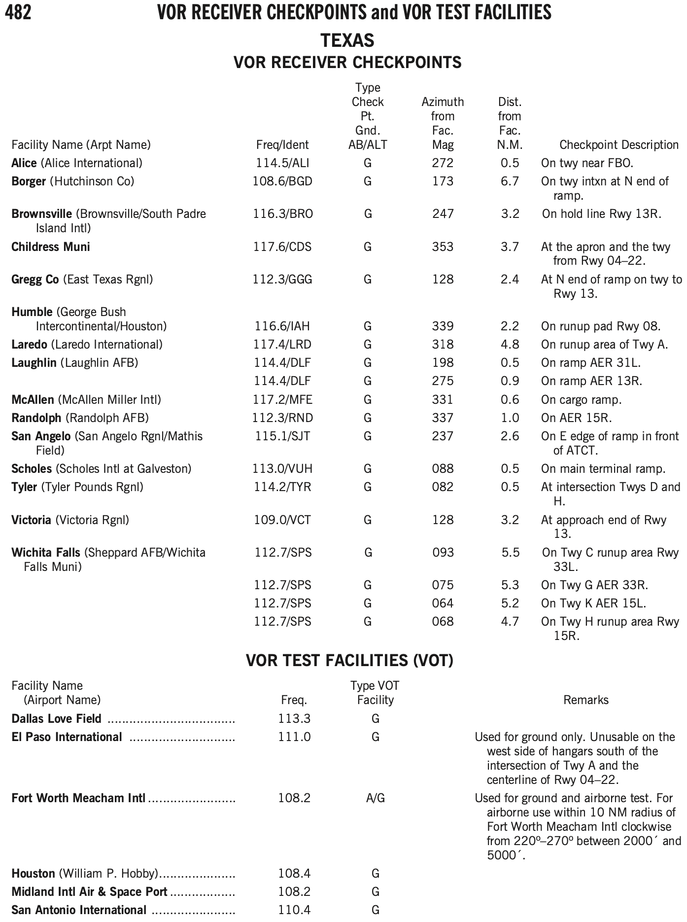
- Can find VOT facilities and VOR checkpoints in the chart supplement.
- Log the results of the VOR accuracy test in the aircraft logbook or other record including the PADS acronym:
- P - Place
- A - Accuracy (bearing error)
- D - Date
- S - Signature
- VOT is the most convenient way to perform a VOR check if your home airport happens to have one
- Similarly, ground checkpoints are also a convenient option
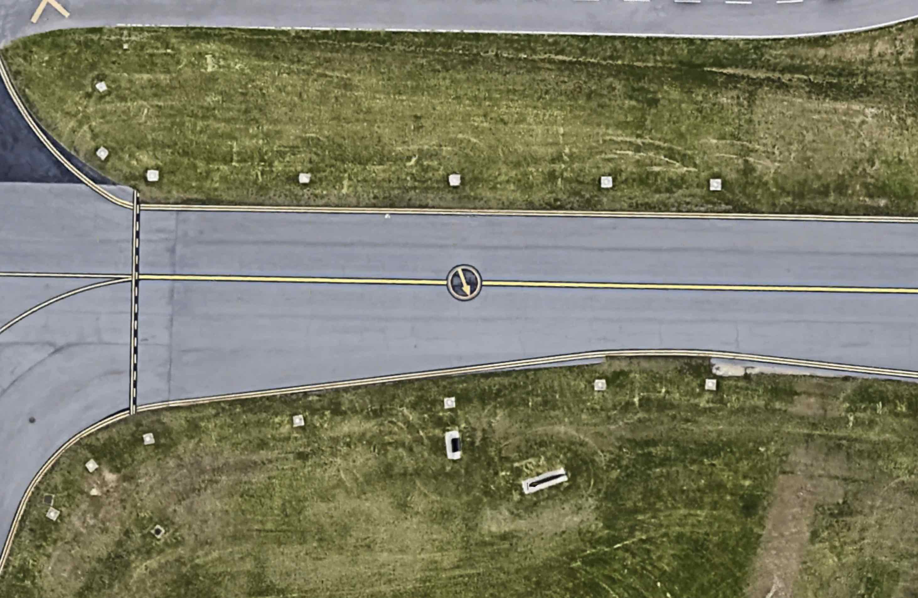
VOR Ground Checkpoint
- Has a sign in front of the arrow with the radial and frequency
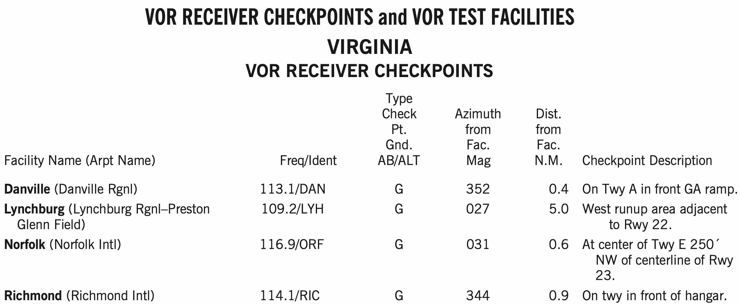
VOT Check
- A VOT is a facility located at certain airports that emits a signal that can be used to test a plane's VOR receiver
- The VOT signals are generally designed to be used while on the ground, but some are designated as usable in air, with certain restrictions
- This information can be found in the chart supplement
- Dial a course of 180° in using the OBS, should see the needle center (within +/- 4 degrees) with a
TOindication.
II.C Instrument Flight Deck Check
- How do you determine if you can legally fly an IFR trip with a piece of equipment inoperative?
- Is the equipment required by a Minimum Equipment List (MEL) approved by FAA?
- No Aviation Adventures planes have MEL
- Is the equipment required by a Kinds Of Equipment List (KOEL)?
- G1000/nav com III POHs have KOELS in Section 2 of the POH, operating limitations
- Is the equipment required by a Comprehensive Equipment List (CEL)?
- 172R/S/M/N/P have CEL in Section 6 POH, weight and balance,
Rrequired for flight,Sstandard
- 172R/S/M/N/P have CEL in Section 6 POH, weight and balance,
- Is the equipment required by Airworthiness Directive (AD)?
- If broken part is not required by KOEL/CEL, check it is not requried by 14 CFR §91.205 Instrument and equipment requirements below
- Day VFR (A+TOMATOFLAMES)
- Night VFR (FLAPS)
- Is the equipment required by a Minimum Equipment List (MEL) approved by FAA?
IFR Required Equipment
GRABCARDD
G - Generator
- Or alternator
R - Radios
- Comm and navigation suitable for the route to be flown
A - Altimeter
- Adjustable
B - Ball
- Inclinometer, slip/skid indicator
C - Clock
- With seconds
A - Attitude indicator
R - Rate of turn indicator
D - Directional gyro
- Heading indicator
D - DME or RNAV
- At FL240 and higher if VOR is required
Is the equipment required for your planned IFR flight, e.g. required by the approach you are planning?
If legal to fly with broken part, it must be PLACARDED and either REMOVED or DEACTIVATED
- If it is removed, a new weight and balance might need to be computed depending on the weight of the part
Also a condition to fly with the inoperative equipment is the pilot in command must also determine it does not pose a hazard to flight.
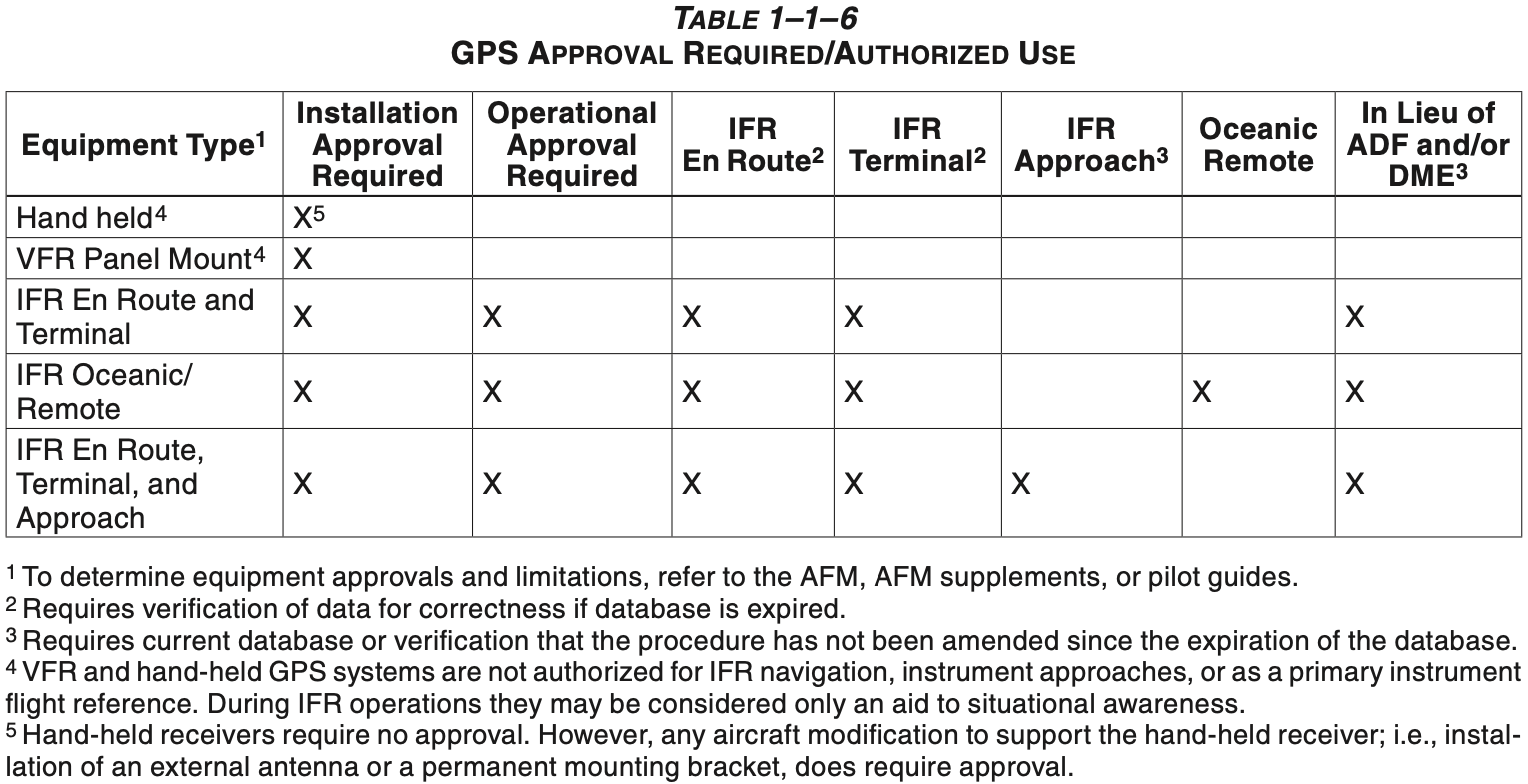
If IFR database: must be current?
- Database must be up-to-date
- Database updated every 28 days
- Usually every 4th Thursday
- Exception
- In AIM Table 1-1-6?
- Verify approaches haven't changed or been amended
- Verify route hasn't changed
- Database updated every 28 days
- Database must be up-to-date
More Questions
- When can a pilot log an instrument approach in IMC? When under foggles?
- Actual past FAF
- Simulated all the way down to minimums
- When can a CFII log an instrument approach?
- A flight instructor may log an IAP conducted by the student in actual IMC
- Approach minimums shown on approach plates in AGL are altitude with respect to what?
- For straight-in approaches AGL heights on approach plates is above TDZE
- On circling approaches when we don't have a specific touchdown point we use airport elevation
- How is touchdown zone elevation (TDZE) defined?
- The highest elevation in the first 3,000 feet of the landing surface
- How is airport elevation defined?
- The highest point of an airport's usable runways measured in feet from mean sea level.
- Bold C on approach - expanded circling minimums
- See front of TPP
- Note: Category A is 90 KIAS or less
- When can we decsend below the MDA or DA to the runway?
- Must be able to make a normal descent to landing
- Flight visibility must be observed to be above minimums
- Be able to distinctly identify one of the following visual references (ATRVTR)
- A - Approach lights
- Approach lights alone only allow descent to 100 ft. above TDZE
- From that point must be able to see any other parts of the runway environment to continue to descend and land
- T - Threshold
- Markings
- Lights
- R - REILS
- V - VASI (or PAPI)
- T - Touchdown
- Lights
- Zone
- Markings
- R - Runway
- Lights
- Markings
- A - Approach lights
- Where is transponder required?
- 14 CFR §91.215(b)(5)(i)
- Above 10,000 MSL, unless witihin 2,500 AGL
- Class A
- Within horizontal limits of Class B mode-C veil (30 nm)
- C airspace
- Within 10 nm of certain designated airports, excluding airspace which is both outside the Class D surface area and below 1,200' AGL
- Flying into, within, or across the ADIZ
- 14 CFR §91.215(b)(5)(i)
- Where is ADS-B required?
- Class A, B, and C airspace
- Class E airspace at or above 10,000' MSL, excluding airspace at and below 2,500' AGL
- Within 30 nautical miles of a Class B primary airport (the Mode C veil);
- Above the ceiling and within the lateral boundaries of Class B or Class C airspace up to 10,000'
- Class E airspace over the Gulf of Mexico, at and above 3,000' MSL', within 12 nm of the U.S. coast.
- What is a "cruise" clearance under IFR?
- You get a block of airspace from minimum IFR altitude up to the altitude in the cruise clearance
- You can climb, descend, and level off at any intermediate altitude within the block of airspace, all the way to your destination under IFR
- Cruise clearance clears you for the approach at your destination
- Note: once you report leaving an altitude within the block during descent, you may not return to that altitude without an additional ATC clearance
- What is VFR on-top?
- A clearance the pilot can request when in VMC over or between cloud layers
- Does not cancel IFR flight plan
- Fly at appropriate VFR altitude
- Adhere to VFR visibility and cloud clearance requirements
- Advise ATC of any altitude changes
- Before a flight, what information must the PIC become familiar with?
- Use the following acronym to remember the important items (NW KRAFT)
- N - NOTAMs
- W - Weather reports and forecasts
- K - Known traffic delays as advised by ATC
- R - Runway lengths of intended use
- A - Alternates available
- F - Fuel requirements
- T - Takeoff and landing performance data
- And any information relating to the flight
- 14 CFR §91.103 - Preflight action
- Use the following acronym to remember the important items (NW KRAFT)
- What lights are required for IFR? What lights are a good idea?
- Recall from 14 CFR §91.205 Instrument and equipment requirements
- Day VFR: beacon
- Night VFR: position lights (and landing light if for hire)
- IFR: no additional lights needed
- In terms of what is a good idea for IFR
- Position lights on
- Taxi light when taxiing, and turn it off when stopping
- See FAA-AC-120-74B - Parts 91, 121, 125, and 135 Flightcrew Procedures During Taxi Operations
- Recall from 14 CFR §91.205 Instrument and equipment requirements
- What are the minimum IFR altitudes we can fly?
- Except for takeoff or landing, or otherwise authorized by the FAA, no person may operate an aircraft under IFR below
- Minimum altitudes prescribed for the flown segment, or if none:
- Mountainous areas: 2,000 ft above the highest obstacle within a horizontal distance of 4 NM from the course.
- Non-mountainous areas: 1,000 ft above the highest obstacle within 4 NM from the course.
- 14 CFR §91.177 Minimum altitudes for IFR operations
- Except for takeoff or landing, or otherwise authorized by the FAA, no person may operate an aircraft under IFR below
- What are the dimensions of an ILS?
- Localizer: Usually 5° total width, with the width at the threshold being 700 feet.
- Glideslope: Usually a 3° slope, with 1.4° total width.
- When can you descend to the next instrument approach segment?
- When cleared for the approach and established on a segment of a published approach or route.
- What are the dimensions of a victor airway?
- From 1200 AGL - 17,999 MSL and 4nm from each side of centerline
References
- AIM 5-3-2 Position Reporting
- AIM 5-3-3 Additional Reports
- 14 CFR §91.183 IFR communications
- 14 CFR §91.187 Operation under IFR in controlled airspace: Malfunction reports
- YouTube FLY8MA.com Ep. 201: IFR Low Enroute Charts Explained | Basics Part 1
- YouTube FLY8MA.com Ep. 202: IFR Low Enroute Charts Explained | Advanced Knowledge Part 2
- 14 CFR §91.185 IFR operations: Two-way radio communications failure